The extent of two mining tests monitored during DOMES program (OMI and OMA) were regarded as too limited to allow a simple extrapolation to the full-scale industrial exploitation.
As a consequence of the DOMES conclusions, NOAA established stable reference areas in the Clarion-Clipperton Fracture Zone, In these areas environmental experiments and collecting of the background data should be concentrated.
1.4.2 Post-DOMES experiments
The introduction of the reference areas in the CCFZ with known
environmental baselines (DOMES Sites A, B, C) and known natural
conditions and variability established a possibility to estimate
certain long-term impacts. The DOMES experiment sites or the
neighbouring areas were revisited by expeditions (Echo-1, Quagmire-II
in connection to The Acute Mortality Experiment) which observed the
recolonization of the test areas by benthic organisms. Further works
concentrated mainly on the problems recognized by NOAA during DOMES
project, one of the problems being the estimation of the amount of
redeposited sediment which would produce complete mortality of the
benthic community affected (critical dose).
In conclusions, although disputable because of the limited range of the experiments as well as technical difficulties [96], it has been supposed that a sediment coverage of a few cm may be sufficient to cause a near-total burial mortality [81], and that the recolonization of the disturbed areas, although expected to be slow in the deep sea, may be completed within a few years.
The observed recolonization of an artificially disturbed bottom area which took place in a way similar to the mining activities was also the main objective of the German DISCOL experiment in the Peru Basin. The abundance of the benthic organisms after three years was found to be higher than before the disturbance, which may be a normal stage of the recolonization process [78].
The next two experiments, BIE and JET, both in CCFZ, used a specially constructed deep-sea mining simulator to create a resuspension comparable with the one caused by a mining collector, in order to observe the resuspension and subsequent redeposition in a small area of a few square kilometers. In both sites next cruises are planned to observe the long-term impact effects.
The most recent experiments concentrated on the aspects recognized by NOAA as causing severe environmental impacts. They have not changed the impact severity classification as concluded from the DOMES experiment. Some of the uncertainities still remain, especially the reach of the benthic plume and heavy metal uptake by organisms. During all these experiments the disturbed areas were significantly smaller than the areas to be destroyed by commercial deep-sea mining.
1.4.3 Benthic and surface discharge impact comparison
As was shown by the estimations from the OMI and OMA mining tests in 1978 [75], approximately 97% of the sediment mass discharge by the recovery of the manganese nodules will take place in the benthic zone of the ocean, and only 3% at the surface. Since then the technology has been further developed in many countries and the ecological concerns have been taken into consideration. The main progress in reducing the environmental impact is to be observed in reducing the bottom destruction, diminishing the rate of discharge and reducing the amount of tailings. The surface plume can also avoided, when the tailings from the mining process are introduced at some intermediate depth or even at the bottom [4,9]. For mining technologies without collector systems, e.g. continuous bucket line systems, the situation may be, however, totally different, with discharges occurring in the entire water column.
1.5 Modelling overlook
1.5.1 Modelling of the deep sea mining impact
The disturbances induced by the field experiments and tests are rather small in space and duration time when compared to the commercial-scale, long-term industrial exploitation situation. The technical limitations of these experiments are clear and the gained information about the impact does not cover the whole affected area, but is rather limited to a few measurement points. The need to have tools allowing a surface-covering interpolation of the measurements as well as an extrapolation to the industrial scale mining was early recognized. Here the hydrodynamical modelling found its first applications. Further, while appropriate data from the deep-sea were available, the models allowing prognosis of an impact have been developed with various forecast reliability.
The first attempts of modelling the mining plume impact were made by Hess and Hess [26] and Ichiye and Carnes [28]. Further, Lavelle et al. developed an analytical model for the bottom plume [50] and for the surface discharge [48]. They used a simplified model based on an analytical solution of the sediment transport equation, and calibrated it according to the available data from the OMI 1978 mining test [75]. An extrapolation of the test and model results to the industrial scale minig was attempted. Lavelle reanalysed the problem using a two-dimensional numerical finite-difference model in order to include the effects of the bottom boundary layer, particle scavenging by marine snow, and new settling velocity laboratory analyses [74,44]. Nakata modelled the BIE experiment 1993 using a finite-difference 3D-model (unpublished manuscript). Taguchi, Nakata et al. verified a three-dimensional finite-difference model using the small-scale JET experiment data [85]. Numerical modelling in the mesoscale [29,33,30] and large scale [79,80,100] within the TUSCH association activities, and using support data from the DISCOL experimental area, concentrates on parameter studies and scenario computations.
The development tendence from simple analytical to numerical three-dimensional modelling is obvious, not only due to the development of the hardware capabilities and numerical methods, but also due to better understanding of the physical parameters characterising the particulate mass transport in the deep sea.
1.5.2 Models of the deep-sea sediment and/or passive effluent
not related to the deep-sea mining
The environmental impact assessment of human activities in the deep sea was the topic of much research in the past. The state-of-the-art-reports of the GESAMP group [19] and by Nuclear Energy Agency [71,59] bring an extensive overlook over the modelling of the transport of wastes in the deep ocean with special attention to the possible dispersion of nuclear waste from the dumping sites at the bottom. As a classical example of model-oriented data sampling, i.e. in order to provide verification and support data for modelling, the NOAMP (Nord-Ost-Atlantisches Monitoring-Programm, BSH Hamburg) can be pointed out [35,36]. It must be emphasized that experimental methods used for assessment of the suitability of a dumping site for radioactive waste resembles the methods used to estimate deep-sea mining impact at the bottom. The applied numerical modelling is essentialy similar.
The model developed by Gross und Dade during HEBBLE campaign ([21] in [68]) is an example of the numerical sediment transport model in the deep sea applied to the extremal conditions of the deep sea storms. A numerical study of the influence of the suspended sediment on the bottom boundary layer dynamics was given by Adams and Weatherly [1]. As relevant to the subject, also a two-dimensional model of hydrothermal manganese dispersion in the ocean should be mentioned, developed by Lavelle [45], who used data gained by Cowen, Massoth and Feely [15].
1.5.3 Numerical model scales
The marine systems are characterized by well-defined length and timescale domains associated with the hydrodynamic phenomena (so-called spectral windows [66]). If the transport scales of seconds to minutes are important, the small-scale processes as surface and internal wave field or vertical structures must be resolved by the model. For transport scales from hours to weeks the mesoscale processes as inertial oscillations, tides, diurnal variations and finally mesoscale eddies are important. The lower scale processes are taken into consideration by taking appropriate diffusion coefficients. If the large transport scales from months to years are modelled, the mean circulation in the oceanic scale, and seasonal or even climatic processes must be taken into consideration. The time scale is followed by the spatial resolution; from meters in the small-scale models through a hundred meters to kilometers in mesoscale up to a few hundred kilometers in the large-scale (or global) models.
In the particular case of deep sea mining discharges, the numerical models can be divided into following three classes:
- Large-scale models. They describe the long-term (months to
years) influence of the mining discharges. They may allow a
simulation of a long-term commercial scale activities and their
impact on entire ocean basins or even the global ocean. They operate
with large timesteps (i.e. a month) and use a very simplified bottom
topography. They are verified using the overall oceanographic data
from the world ocean. No data depicting global scale deep-sea mining
impact is available.
- Mesoscale models. They concentrate on the timescales and
areas where the greatest impact is to be awaited, i.e hours to
weeks giving transport path lengths up to a few hundred
kilometers. The primary effort is to simulate the mesoscale
processes although in the previous models current time variabilty
was neglected. Due to the position of the mining areas, they are
regional models with open boundaries, where the boundary
conditions are given by large-scale circulation conditions. They
use different techniques to obtain the mesoscale current
variability. For the timescales up to a few days they are the
only models which may be validated using the data from the
experiments which took place in areas up to a hundred square
kilometers during one to two weeks. The time and space resolution
of these models must allow a description of the plume near the
discharge, starting from the time when the ambient current begins
to dominate the plume transport, i.e., after the first phase of
dispersion by the eddies in the wake of the machine and the
subsequent gravitational collapse in the direct vicinity of the
source. The upper scale limit is defined by the range of the
hydrodynamic processes described by the model. E.g., a model
reproducing inertial oscillations, tides, diurnal variations
superimposed on a stable geostrophic component can be applied to
transport times up to a few days. Above this limit the mesoscale
eddy field must be simulated.
- Small-scale models. They describe the direct neighbourhood
of a mining collector or a discharge pipe. They are
high-resolution models with a complex geometry, which describe
sediment transport in the turbulent velocity field influenced by
the movements of the mining device, e.g., the wake eddies behind
it. Such near-field models may be useful for the construction of
devices with minimum possible discharge to the water column and
verified using data from the prototype tests.
2. Model-oriented data collection
This chapter will select parameters, which describe physical phenomena relevant for the mathematical modelling of the deep sea mining impacts. For the acquisition of these data and other subject-related information the model-specific needs should be regarded. Experimental methods and the ways in which the data are incorporated into the models are critically overviewed. Most of these remarks are also valid for collecting data describing the overall pre-impact conditions in the potential mining areas.
2.1 Impact parameters to be estimated
The numerical models mentioned in this report serve to simulate
the dispersion and resedimentation of sediment plumes generated in
deep ocean mining areas. The impact parameters can be estimated by
hydrodynamic modelling and are described in the following text.
The bottom and surface plume residence time or area.
Chronic exposition of organisms to the fine resuspended particulates
(sediments, ore particles) as well as to other effluents can be dealt
with in models by the estimating persistence of a given particle
concentration in the water column, or over a given bottom area.
Effluents are dissolved or particulate substances mobilized from
interstitial or pore water in possible interaction with sediments.
The models must be able to simulate unsteady concentration values
over bottom topography and dispersed by currents varying in time and
space, estimating the duration and extent of the plumes before they
resettle at the bottom or dilute to the concentrations comparable to
the ambient value. No accepted norms exist, stating the limits of the
excess concentration (total concentration minus ambient one) and its
persistence time, which are harmful for the organisms. Therefore, the
residence time of the plume is usually defined as the period in which
the resuspended mass is significantly reduced, e.g., one order of
magnitude, twice, e-fold, or the period in which
concentrations reach the values comparable with the ambient ones. The
area of the ocean bottom affected by concentrations significantly
greater than ambient can be given as the measure of the area affected
by the plumes. In the case of the surface plume, the considered area
is often reduced to the surface mixed layer (above and with the main
pycnocline), with concentrations at the surface and just above
pycnocline as the representatives. The period in which the surface
plume hinders the penetration of the solar radiaton is also an
important parameter.
Resettling of the resuspended sediments causing blanketing of
areas directly near the collector tracks, as well as at some
distance, is to be estimated by the netto deposition
thickness, which can be obtained by computing the resedimentation
and erosion rates. This is given as the netto deposited mass per
surface or eventual thickness of the fresh deposit. This parameter is
thought to be the most important in estimating the mortality of the
benthic organisms at a distance from the collector tracks. No norms
are given for the limit of the sediment coverage thickness above
which the sediment burial is harmful for the benthic organisms.
Relationships between the physicochemical parameter ranges and the eventual impact severity are unclear in the case of the benthic organisms. The ecology of the deep sea and its interrelationships with the remainder of the oceans are not yet well understood; research in this field has just begun [88].
2.2 Parameters for mathematical modelling
This section has an aim to select the model parameters in the
mathematical description of the particulate mass transport. The
sediment transport equation in a velocity field (u, v,
w) is given as
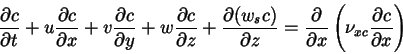
where c is the dry mass sediment concentration, ws is the settling velocity,
However, the presence of the discharged particulate mass in higher concentration influences the ambient current. The suspended particles change the global fluid density, causing stratification, buoyancy effects, and density currents. The intensity of these phenomena depends mainly on the strength of the density contrast between the discharge and the surrounding fluid. The persistence of buoyancy effects depends on the mixing rate, which diminishes flow-driving density gradients.
When sediment is discharged in larger concentrations into a deep-sea boundary layer, the reduced vertical mixing due to the stable stratification has an important influence on the concentration distribution in the first stages of plume transport. Usually the suspended sediment concentration in the bottom boundary layer and in surface mixed layer can be treated as the only factor generating stratification and possibly density-driven flows.
The observations of the resedimentation pattern of the bottom plume allow to suppose that density-driven flow plays a role in the first transport stages of the discharged sediment. The time and space scales associated with the gravitational plume collapse remain unmeasured, but intensive resedimentation is found up to 100 m or more upstream of the collector tracks. This has been interpreted as the consequence of density flows (density up to 3% above ambient, OMI/OMA tests [50]). After the first phase of dispersion by the eddies in the wake of the machine and the subsequent gravitational collapse in the direct vicinity of the source, the ambient current prevails as the main transport mechanism due to relatively low concentrations [29].
By the discharge of dense tailings form the mining process in the
bottom zone, the concentrations of the particulates may be actually
so high that, depending on the bottom topography, even intensive
density currents are predicted [9]. In the
surface zone the discharge will be much colder than the surrounding
waters. By higher discharge rates and diminished mixing density
contrast must be also taken into consideration (0.8% to 1.2%. [48,49]).
The
dependence of the fluid density on the dry mass sediment
concentration c (in kilograms per cubic meter) is usually
taken as
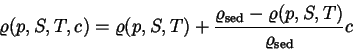
where
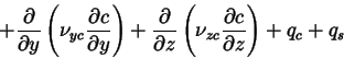
The boundary conditions of the equation (2.1) are described as follows. The net
sediment flux at the surface is zero:
![\begin{displaymath} \left[ w_s c - \nu _{zc}
\frac{\partial c}{\partial z} \right]_{{\rm surf}} = 0
\end{displaymath}](img8.gif)
Erosion and sedimentation at the sediment-water interface are usually taken as the functions of the bed shear stress
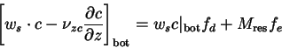
where the probabilities for deposition and erosion are given by [39]:
The resuspension rate Mres and the critical stresses
The presented above mathematical analysis of the problem yields the following list of the parameters needed to describe the particulate mass transport:
- current velocity field (u,v,w);
- turbulent diffusivity tensor
 ,
,
- discharge rate qc,
- scavenging rate qs,
- settling velocity ws,
- particle constituent density
 ,
,
- ambient fluid density
 ,
,
- bottom shear stress
 ,
,
- critical stress for the deposition
 ,
,
- critical stress for the erosion
 ,
,
- resuspension rate Mres.
2.3 Support and verification data
The data needed for modelling can be divided into the verification data and support data. Roughly saying, the verification data sets are used in order to compare the model results with the measurements. In the case of deep-sea mining they are data sets describing the transient three-dimensional plume dispersion (concentrations and particle characteristics) and, simultaneously, the velocity field.
The support data are all physicochemical data sets, which are used as input data describing the initial conditions, as well as the data needed to drive and controll the model, e.g. the time-dependent boundary conditions. They are such parameters as the discharge rate, initial current regime, sediment settling velocity. The support data are also used to adapt or calibrate a given (and verified) model to new conditions: e.g. to a new application field or other discharges.
The verification data are needed during the process of the model
development and verification. Once verified, the model can be used
for reliably forecasting the impact under similar conditions as
during the verification. The complexity of the needed data sets
depends on the range of the physical phenomena which are taken into
consideration in a given model. In the case of the deep seabed mining
impact modelling, the data appear to be collected during small-scale
tests. They are often conducted in specific circumstances, which in
turn are dictated by technical limits of the experimental methods. Up
to date, verification is possible only in this limited scope. All
extrapolations to the commercial scale mining will remain unverified
until the mining actually commences.
The main needed support data describe the main physical phenomena which must be taken into account in the sediment transport due to deep sea mining discharges. Their role in the mathematical description of the transport processes is illustrated in section (2.2). They are listed as follows:
- Current velocity field. It is obtained by short- and long term
current measurements in different space and time resolutions. The
short term measurements should give information especially on the
bottom or surface boundary layer characteristics and variability. In
the case of the surface mixed layer, the correlated wind measurements
are important. The long term measurements should provide information
e.g. on mesoscale variability and seasonal current changes and other
effects, e.g. upwelling or downwelling, as well as the bottom or
surface layer characteristics. The time and space resolution should
be appropriate for the given model scale and application domain. The
current measurements are used in models in order to:
- detect the most important hydrodynamic phenomena for given transport scales, which are then modelled in a deterministic way, or
- construct typical current scenarios, or
- incorporate them directly into the models.
- The current measurements should provide also the possibility of
estimation of the turbulent eddy viscosities in the area using
statistical methods, and assuming that the sediment diffusivity has
the same value. Other possibilities are observations of the
distribution of the natural radionuclides or effluents from known
sources. Measurements of the time development of the concentration
distribution itself, with known settling velocity can be also used.
The variability of the diffusivity is also important, e.g. in the
bottom boundary layer. Very special attention must be paid to the
vertical diffusivity, the factor which can balance the settling
velocity of the sediment.
- Bathymetry of the area in sufficient resolution for a given
model scope and scale is needed in order to simulate the topographic
influences. Due to the technological aspects, the mining will take
place preferably in rather flat bottom areas.
- Global hydrographical characteristics of a given part of the
ocean (tidal characteristics, currents, winds, seasonal variability,
etc.) give additional information on the site-specific current
measurements.
- Salinity, temperature, and turbidity profiles provide the
ambient density field. They are especially important for modelling of
free surface discharges, where the thermocline is a boundary between
two areas of very different hydrodynamical characteristics.
- The rate, spatial and temporal form of the discharge will
remain unclear until the real technology is used. However, the
maximal discharges can be estimated from the sediment amount
available for deposition at the bottom and discharge height. The
initial concentration and density contrast to the surrounding waters,
temperature and salinity of the discharge must be also measured. For
estimation of the bottom sediments characteristics the well-known
mineralogical and ground mechanics methods are used. The density of
suspended, aggregated, cohesive sediment particles in situ is,
however, one of the most difficult parameters to be estimated. The
sediment source must be idealized with greatest care in the
mathematical model according to the model resolution and timescales,
e.g. in a mesoscale or large-scale model.
- The scavenging rate is given by observation of the ambient
natural particle concentrations, characteristics of these particles,
particle flux magnitude, their composition, usually using sediment
traps and water probes. Scavenging is recognized as one of the
possibly most effective agent in removal of the diluted plumes away
from the source, consisting of very slowly settling, finest
particulates. Its relation to the ocean surface productivity is
clear, but not known in detail.
- Bottom shear stress can be obtained from bottom-near
measurements of the velocity profile or estimated from the bottom
roughness.
- The critical stress for the erosion can be estimated by
observation of the natural and artificially caused erosion processes.
The velocities measured in the mining areas are far lower than the
velocities which may cause a stress large enough to cause erosion.
This kind of the benthic boudary layer is defined as low-energetic,
in contrast to the high energy boundary layer, where a strong erosion
and subsequent deposition exists due to the unregularly appearing
stronger currents (benthic storms). Therefore, it is usually assumed
that in low-energetic BBL no erosion of the deep-sea bed occurs. Very
little is known about the erosion of freshly deposited sediments from
mining discharges.
- It is very little known about the critical stress for the
deposition. For the reasons mentioned above, the probability of
deposition is usually taken to be equal one in the low energetic BBL.
That means, each sediment particle reaching the bottom will be
deposited.
- The resuspension rate Mres is usually
obtained from empirical formulations, depending on the amount of the
material available for erosion at the bottom in given conditions. It
is set to zero when all this material eventually erodes.
- The sediment settling velocity in situ is the most complex
parameter in this listing. Model-oriented measurements should provide
information on:
- sediment settling velocity distribution in situ;
- diameter distribution: primary particles and aggregates in situ;
- other primary particles and aggregates characteristics: aggregation level, constituent and apparent densities, sphericity, porosity, strength;
- characteristics of the flocculation and break-up processes in the water column in situ, in the plume;
- ambient fluid turbulence characteristics;
- the role of the organic substances, and interaction between suspended particles and living organisms.
The measurements should be made in the different plume parts of various age and at different points.
Because of the experimental difficulties to estimate the above listed parameters in situ, most of them are known almost only from the laboratory experiments. In situ measurements are still very scarce [61,84]. There are three usual methods to deal with the settling velocity ws, a parameter ranging from 10-3 m/s to 10-7 m/s for deep sea sediment particles:
- to assume ws to be constant in time and space, and equal to a weighted mean settling velocity of the composite sediment spectrum;
- to use an empirical formula for ws, e.g. as a function of concentration and turbulence characteristics [58];
- to use appropriate number of sediment classes characterized by settling velocities without (non-cohesive case), or with interaction among various classes (cohesive case).
Most of the deep sea sediments from the nodule mining areas have a particle size distribution showing that most of the particles have diameters d < 60µm, which means that the cohesive forces between the particles cannot be neglected [60]. An empirical model for the settling velocity would be an effective solution to describe the mean settling velocity variability due to flocculation and break-up processes. This is based on the assumption that the flocculation and, therefore, also the mean settling velocity are proportional to the suspended sediment concentration and turbulence characteristics [17,52,53,57]. Unfortunately, data about the cohesive properties of the deep-sea sediments in situ are too scarce to allow applying of this formulation in a nonspeculative way, especially in the case of the deep-sea mining discharges [61]. Laboratory experiments using sediments from the equatorial Pacific mining areas have shown that flocculation effects are significant at concentrations above 100 mg/l [74].
Due to the turbulence conditions in the low-energy bottom boundary layer [65], the flocculation phenomena depend mainly on the differential settling of the different size sediment particles. Brownian motion and turbulent shear influences can be neglected [30]. The support data are, however, not available. The possible flocculation effects may, therefore, only accelerate the deposition compared to the non-cohesive case, since the break-up effects are insignificant. Nevertheless, it should be mentioned that higher concentrations, with stronger flocculation effects, are found in the vicinity of the collector only. Consequently, flocculation may be unimportant in the diluted plumes at a greater distance from the source. Here the scavenging by the rapidly sinking ambient particles (marine snow) may be important in some areas.
The possibility of using a spectrum of noninteracting sediment classes characterized by different settling velocities is at present disputable, because the dependence of the plume concentration on the settling velocity spectrum is insignificant when compared with the uncertainties associated with other parameters [44]. An attempt to describe flocculation effects by assuming an interaction between classes is very difficult due to the uncertainity in the interaction rates and mass conservation problems.
Therefore, up to date, most of the studies use constant mean settling velocities obtained from the particle mass, density and diameter distribution. Parameter studies with a broad range of constant settling velocities are performed in order to estimate the uncertainities.
The verification data must describe these parameters which are to be estimated by the models described in section 2.1, i.e. data describing the persistence of the suspended sediment in a given area, as well as the resedimentation development. These parameters must be measured simultaneously with other parameters, i.e., with velocity field and sediment settling velocity in situ. These data are used for the verification of the impact prediction, so they should illustrate the three-dimensional, transient concentration field and the two-dimensional, time-dependent resedimentation flux. The parameters characterizing the suspended sediment particles in the plume in various points and in different transport stages are of equal crucial importance, as the support data.
2.4 Experimental methods
This section provides a short overview of the experimental methods used to obtain the model support and verification data. It is based on available literature and does not concentrate on their description, but on technical advantages and limitations of the applied devices.
- Velocity field, bottom stress and turbulence parameters. The
usual method is to use anchored moorings or other firm devices
(tripods) with attached current meters at different depths (Euler
method). Another method is to use floats balanced to stay at a given
depth (or at the surface) for remote observation of their tracks
(Lagrange method).
In order to provide a long-term pattern of the horizontal (2D) ocean currents the classical and robust mechanical rotor meters are a usual choice. The DISCOL measurements can be cited [34] as an example, how much information can be obtained from only one mooring with five meters. Such meters were applied during essentially all deep sea mining experiments. Their advantage lies in the robustness, easy calibration and reliability. Their disadvantages are the threshold velocity which may be in the range of the deep-sea velocities, data capacity and resolution. The measurements are not usually done in real time.
Another discouraging aspect is the fact, that even for rather small areas of BIE and JET experiments (section 3.5 and 3.6), a whole array of the meters at different depths is needed in order to obtain the bottom current variability, affected and unaffected by the bottom topography.
By estimating the parameters of the bottom boundary layer (including turbulence, speed, skin friction, drag, suspended sediment influence on the flow field), meter arrays measuring all three components of the velocity with an appropriate resolution are needed, as acoustic ones [20,95], or special devices, working with hot wires and hot films [22]. They are usually applied for short-term measurements with high time and space resolution. Their main advantage is high resolution and three-dimensionality. Main disadvantages exist due to the fact that they are usually prototype devices needing complex adjustment, and that they are sensitive to damage.
The float experiments, especially when accompanied by current measurements from firm positions, are a valuable source of information for the mesoscale and large-scale flows over complex topography, as well as eddy fields at depth [36] and on the surface [38]. By measurements of surface currents, correlated wind and sea roughness measurements are essential. Sattelite-tracked long-term surface and real time float experiments correlated with meteorological observations is much advanced, as the examples of World Ocean Circulation Experiment (WOCE) [97] and Tropical Ocean Global Atmosphere / Tropical Atmosphere Ocean (TOGA-TAO) [24] confirm.
- Bathymetry in the depths typical for the manganese nodule
fields can be obtained by acoustic measurements with appropriate
resolution using a reliable and advanced technology. They require,
however, many device tows and considerable ship time before an
area-covering picture is obtained.
- If the interdisciplinary works are concentrated in the
reference areas (as for CCFZ), a relatively complete global
oceanological characteristics can be obtained [10].
- Devices for obtaining salinity, temperature, turbidity profiles
as a function of depth are reliable, but the measurements are
time-consuming, when characteristics of a larger area are needed.
- The discharge rate at the surface is easily to be measured, at
the bottom it can be estimated depending on the technology. The
estimation of the initial form of the discharged bottom plume is
difficult and may require laboratory or shallow-water tests using
original mining collector prototypes.
- For suspendend sediment plume tracking and resedimentation,
nephelometers, based on light transmission measurements, and devices
based on acoustic backscattering, accompanied by sediment traps,
water and sediment probes, underwater photography, in situ settling
tubes and current measurements are being applied. Nephelometers and
acoustic devices are used usually in fixed positions, providing time
series and concentration profiles at a given point. At these
positions water samples and/or sediment traps are placed. Transects
through the plume has been made only for the surface discharge,
because of its relatively easy localization [49]. As a description of the state-of-the-art
experimental methods for measurements of the suspended sediment
transport in natural deep-sea conditions the we refer to HEBBLE
experiment literature [68,69]. The adjustment and calibration of these
devices, mainly prototypes, as well as the result interpretation is
still a matter of research. The sedimentation, in addition to
sediment probes and sediment traps, can be observed using remote
cameras, and be dealt with using chemical and radiochemical methods,
e.g. [63,18].
- Ambient particle concentrations can be obtained by turbidity
measurements, associated with water probes. Methods to obtain
scavenging characteristics exist (e.g. [60,6]), there are, however, great uncertainities.
The results of the JGOFS (Joint Global Ocean Flux Study) will
hopefully bring a better understanding of vertical fluxes of the
particulate matter in the ocean and their relation to the upper ocean
productivity.
- Critical stresses for erosion and deposition [39] are the least-known parameters for the deep
sea sediment transport [47,46]. In modelling usually simple assumptions
for erosion and depositions are introduced [27,21,30].
- Settling velocity and other sediment characteristics are
parameters, whose estimation in situ creates most difficulties. The
usual method for estimating the mean settling velocity and/or the
particle diameter spectra is to use a settling tube by controlled
probe concentration, the Owen tube, light scattering sensors (optical
settling tube), gravimetric methods, and Coulter counter (an
impedance-pulse particle volume sensor) [53,60,61,84,99].
Other parameters are obtained by geological methods, microscopy, or settling in a fluid of a controlled density gradient (constituent density) [7]. The main problem is presented by the relation between the laboratory results and the reality in situ, e.g. the role of the organic matter in sediment characteristics [72,60]. Due to the composition of the deep sea sediments, their cohesive properties cannot be neglected [60]. Since the flocculation and organic matter influences are difficult to reproduce in the laboratory, a development of non-destructive, in situ particle spectra and settling velocity analysers are a subject of research. Deep-sea measurements are still very scarce (Remote Optical Settling Tube, ROST, [84], Benthic Autonomous Settling Tube, BEAST, [61]). The progress in dealing with description of the sediment transport processes in estuaries, in situ, [17,52,55,53], [58,57] and development of new laboratory methods [7,84] will probably allow also progress in deep-sea matters. Up to date, the parameters used in models are usually estimations or laboratory results with various relevance to the situation in situ.
3. Critical overview of field works and existing models
This chapter contains a critical overview of the subject-related field works and models based on their results. The aim is to provide an outline of the existing technical possibilities, trends and experimental methods in their chronological development. It depicts also the development of the particulate mass transport models in interaction with the existing support and validation data as well as ever-growing possibilities of computer methods.
The described tests and experiments during which model-relevant data were collected are shortly summarized in Table 3.1. The existing impact models are listed in Table 3.2. The description is divided into three logical parts: (1) the modelling based on the mining test data, collected during the DOMES project with discussion, (2) Discol, BIE and JET experiments with applied models and discussion; (3) final conclusions.
|
3.1 OMI and OMA tests 1978
Two successful and at presently unique pilot-scale tests conducted during the DOMES project by Ocean Mining Inc. (OMI) and by Ocean Mining Associates (OMA) have provided the most valuable information on the impact caused by deep sea mining, because real mining devices under real conditions were used [14,76,75,49]. During OMI test (March to May 1978, DOMES Site A, at 9°N 151°W) 900 t of nodules were mined from a depth of 5100 m during 102 h of actual collector action; OMA mined 500 t near 15°N 126°W (DOMES Site C) from 4300 m during 18 h collector work. These tests were accompanied by field works during the DOMES Project and provided data essential for the impact assessment. In addition to the background geological, biological and oceanographic data acquisition, also the parameters of the mining discharge at the surface, as well as at the bottom were measured. Ozturgut et al. [75] basing on the tests results presented the commercial scale discharge estimates.
Using data from the tests, two analytical models of the discharged plume have been developed in which particles settling with constant mean settling velocity advect and diffuse in a medium characterized by uniform, horizontal current and uniform (but not equal) horizontal and vertical diffusivities.
3.1.1 Bottom discharge
Lavelle et al. developed a model for the bottom plume [50], based on an analytical solution of the time-dependent transport equation for the particulate matter. The deposition processes at the bottom, assumed to be a flat plane, were characterized by the adsorptivity index describing the particle deposition probability.
The model parameters were measured using nephelometers and current meters moored at fixed, different levels above the bottom. The collector discharge was not known exactly. Also only approximations based on optical observations of the deposition away from the collector tracks were available (photographs analysis). The model was used to obtain the parameters which remained unknown during the tests, with special attention to the settling velocity and near-bottom vertical diffusivity. The effective mean settling velocity was estimated by least-squares method to be relatively large, about 10-3 m/s, i.e. much higher than expected for the pelagic sediments, with a broad settling velocity spectrum. The magnitude of vertical diffusivity was found in a similar way to be 4×10⁻³ m2/s, consistent with the previous measurements from this area [13]. Horizontal diffusivity was taken from the previous deep sea estimates in the length scale of 1 km (1-10> m2/s [71]), the mean current velocity was constant and equal 2 cm/s.
The form of the discharge, modelled as a linear mass source with
an exponential vertical discharge distribution ![]() , was
discussed, and a distribution, with the discharged mass concentrated
directly above the bottom was assumed (70% discharged mass within the
first half meter of the water column, obtained for
, was
discussed, and a distribution, with the discharged mass concentrated
directly above the bottom was assumed (70% discharged mass within the
first half meter of the water column, obtained for ![]() ). This form of mass discharge distribution was contributed
to the effects caused by density currents. As the evidence of the
density current existence the optically detectable deposition found
even above 50 m upstream from the collector tracks was pointed
out. The action of these currents, as well as the incomplete
disaggregation by the collector of the consolidated sediment from the
bed, were made responsible for the substantial amount of deposition
found near the collector track. The discharge rate was computed from
the estimated collector sediment intake (collector of a width
2.4-3 m, moving at a speed of 0.25 m/s and cutting to a depth of
0.1 m in sediments with 18% solid contents and solid density of
2680 kg/m3) in the range of 30 to 40 kg/s. Such
a discharge yields a concentration of approx. 10 g/l immediately
behind the collector.
). This form of mass discharge distribution was contributed
to the effects caused by density currents. As the evidence of the
density current existence the optically detectable deposition found
even above 50 m upstream from the collector tracks was pointed
out. The action of these currents, as well as the incomplete
disaggregation by the collector of the consolidated sediment from the
bed, were made responsible for the substantial amount of deposition
found near the collector track. The discharge rate was computed from
the estimated collector sediment intake (collector of a width
2.4-3 m, moving at a speed of 0.25 m/s and cutting to a depth of
0.1 m in sediments with 18% solid contents and solid density of
2680 kg/m3) in the range of 30 to 40 kg/s. Such
a discharge yields a concentration of approx. 10 g/l immediately
behind the collector.
A large discrepance between the real advection time of the plume and the one obtained by the model was found. The plume observed at a distance of 18 and 21 km away from the center of the mining area was advected with the mean velocity almost twice the current velocity measured at the mining site. It was interpreted as an evidence of short distance current spatial incoherencies during the test.
Under reasonable assumptions, an extrapolation of the test was used to forecast the resedimentation and benthic plume caused by a continuously working collector in the envisaged commercial mining scale [75]. The model was calibrated as described, and predicted resedimentation larger than 1.4 mm within 200 m from the track. Deposition of 0.1 mm is not found beyond 600 m. Within 10 h the relative concentration at the bottom is reduced by two orders of magnitude, within 50 h by three orders. After 800 h the total load in the water column is less than 10-3 of the discharged mass. The plume exceeding the ambient concentrations (6 µg/l) may extend up to 160 km away from the mining area by constant ambient current of 4 cm/s. Concentrations higher than 0.5 mg/l are found only within 10 km from the tracks.
3.1.2 Surface discharge
Further, Lavelle et al. developed analytical models for the surface discharge [48,49]. The purposes of their work were: to set down theoretical models of settling plumes in the ocean surface layers; to investigate the role of the pycnocline in retarding the settling of fine particles; to use the models to forecast the scales of the commercial mining plumes; to assess the reduction of solar radiation below the sea surface by the discharges.
The average discharge flow by airlift tests was 100 l/s (pump: 160 l/s), with total particulate concentrations from 5.8 to 12.1 g/l, mean discharge during the tests 8.4 g/l and mean solid discharge 1.1 kg/s. The volume fraction concentration ranged from 0.25% to 0.55%, based on the specific density of the non-nodule solids of 2700 kg/m2 [10]. The discharge temperature was 3° to 9° higher than the bottom water temperature (1.44°) and 16° to 22° lower than the surrounding surface water (26°). The salinity was assumed to be equal to the salinity of the bottom water, 34.68 ppm or 34.72 ppm. Bulk density of the discharge was 1030-1034 kg/m3, larger as the surface layer density of 1022 kg/m3 by 0.8% to 1.2%. The ambient particle concentration in the test area is 30-40 µg/l with a variation of 10 µg/l.
The solid discharge at the surface consisted of bottom sediment, nodule material resulting from fracturing and abrasion of nodules during collection, transport and waste separation, and macerated benthic biota. The sediment consisted of 68-72% clay by mass. 65% of the disaggregated sediment particles had diameter equal or less than 4 µm [10].
The nephelometer and and Fe-Mn profile measurements have shown that the discharge settled more rapidly than expected for disaggregated fine pelagic clays. The mean value of the settling velocity was 6×10⁻⁴ m/s and vertical diffusivity near 0.1 m2/s.
The waste material with diameter above 64 µm, mainly abraded nodule material, settled very differently in both tests because of the technological differences in the separation method (1.43 cm/s contra 11.9 cm/s). The fraction smaller than 64 µm contained mainly sediments, but also nodule material. Settling experiments in a settling tube with 31.5% artificial seawater have shown a general dependence of the settling velocity on the initial concentrations in the settling tube, which has been attributed to the concentration-dependent particle flocculation. For concentrations between 3400 mg/l and 176 mg/l, the mean settling velocities for this fraction varied from 3×10⁻⁴ m/s to 2×10⁻⁵ m/s. The conclusion was that the flocculation could play a role in in situ settling of the plume, provided that the concentrations were high enough and that there was enough time for flocculation processes to take place.
The developed analytical model was used to estimate the effects of a commercial scale mining plume at the surface, for transient and steady-state solutions, using a mean settling velocity of 6×10⁻⁴ m/s and a vertical diffusivity of 1×10⁻¹ m2/s, a horizontal diffusivity of 10 m2/s [13,71], and an advection velocity of 0.25 m/s. The pycnocline was incorporated into the model by applying a discontinuity in the vertical diffusivity at 50 m depth (diffusion floor). The density effects were not taken into the consideration, because the discharge takes place from a moving vessel, and is relatively small. Density differences were in the range of 1%. The discharge rate was assumed to be 28 kg/s from a vessel moving with a speed of 1 m/s.
The vertical distribution of the discharge was taken to be
exponential ![]() , with
, with ![]() in order to reproduce the vertical
concentration gradiens in the vicinity of the source. The predicted
plumes with sea surface concentrations higher than 1 µg/l (in
surroundings of the ambient concentration of approx. 30 µg/l
detectable only by the Fe or Mn enrichment) would be quite
narrow, i.e. 10-20 km and would extend up to about 100 km in
the mixed layer. Light levels will be reduced, but the plankton would be
unlikely to experience substantially reduced light levels for more than
80-100 hours.
in order to reproduce the vertical
concentration gradiens in the vicinity of the source. The predicted
plumes with sea surface concentrations higher than 1 µg/l (in
surroundings of the ambient concentration of approx. 30 µg/l
detectable only by the Fe or Mn enrichment) would be quite
narrow, i.e. 10-20 km and would extend up to about 100 km in
the mixed layer. Light levels will be reduced, but the plankton would be
unlikely to experience substantially reduced light levels for more than
80-100 hours.
3.1.3 Accumulation of particles at the pycnocline
In the previously described modelling of the surface plume the presence of the pycnocline was incorporated through a discontinuity of the vertical diffusivity at the base of the surface mixed layer (a diffusion floor, [16]). The model did not show accumulation of the particles at the pycnocline, but the data suggested otherwise [49]. The likelihood that the discharge would reside on the pycnocline was investigated by laboratory measurements [73]. Mining waste was introduced into a two-layer laboratory settling column illuminated by laser light. The experiment was repeated for polystyrene particles of uniform density, shape and size to further study the settling in the density interface. The results have shown that the mining waste particles (essentially deep-sea pelagic clays and some abraded nodule fragments with very low organic content) do not have sufficiently low density to accumulate on the pycnocline although a density interface can temporarily concentrate settling particles. The discrepance to the data recorded in situ was attributed to current variable magnitude and shear (unmeasured) [49]. It was stated that a measurement of the wet density spectra of any oceanic discharge is necessary to accurately assess the possibility of particles accumulation on a density interface.
3.1.4 Flocculation, aggregation, density influence
From the observations of the OMI and OMA surface plumes a relatively high settling velocity of particulates (in the order of 6×10⁻⁴ m/s) was calculated. This rapid settling was attributed to flocculation of the settling material. This explanation was supported by the data obtained from the laboratory settling measurements for different mining waste initial concentrations in the settling tube [49]. The alternative theories were assessed to be less likely. They explained namely, that the observed rapid settling in situ (1) reflects discharge in the form of aggregates of relatively large size, which withstood reduction by the shear and turbulence in the pipeline or reflocculated rapidly thereafter; (2) is due to a convective settling due to density difference between the cold plume of fine particles and the surrounding warm surface waters.
3.1.5 Further discussion and
reinterpretation of the test modelling results
3.1.5.1 New surface plume estimations
As the new information about the settling velocity spectrum became subsequently available [72,73,74], the predictions about the extent of the sediment plumes were revided, especially in the case of the surface plume [43]. The test minig data used previously allowed estimation of a mean settling velocity only. The measurements have shown that a substantially larger sediment fraction has a settling velocity smaller than the mean value previously estimated. The new mean value was estimated to be 10-4 m/s, previously 6×10⁻⁴ m/s.
The results using other parameters the same as previously [48] show concentrations extending much further downstream. Concentrations of 100, 32, and 10µg/l extend as far as 60, 160, and 500 km downstream respectively, whereas in earlier estimates concentrations of 100 and 10µg/l extended only 6 and 40 km downstream. Additionally, the usage of time-dependent diffusivity narrowed the plume at small distances from the mining ship. A disscussion of the plume spreading for different ship movements, pycnocline depths and currents was given. The plume age at the distance of 160 km from the ship would be 7 days, and over that length of time it is to be expected that some of the particulates would be ingested by plankton and transported down as fecal pellets.
The inconsistency between the nephelometer and Fe-Mn profile measurements, showing a rapid return to the background concentrations and the results using the new settling velocity spectrum were explained by the unconfirmed hypothesis that the Fe and Mn are differentially associated with particles according to their size or to the presence of current directional shear in the mixed layer in windy conditions. The mean large settling velocity inferred from the test data was due to incompleteness of the measurements due to technical problems in monitoring the discharge. The finest particles of very small mass concentrations were undetected by the nephelometers at larger plume ages. It was supposed that they might have little Fe and Mn contents, as well. The role of flocculation effects speeding the settling up was disregarded, because such flocs were not observed in the laboratory experiments.
As a result of further works led by NOAA the likelihood of the adverse effects of heavy metal congestion and assimilation by zooplankton and further potential food chain transfer to higher organisms was assessed to be minimal [77]. The effects of the mining plume on the fish larvae and eggs (tuna) has been also examined and assessed to be of minor importance due to the dispersion and dilution of the effluents [77].
3.1.5.2 Reanalysing the bottom plume sedimentation
The bottom plume predictions were reanalysed some ten years after the tests [44]. The new measurements of the settling velocity spectrum for totally disaggregated sediments were used [74] were used. A simple bottom boundary layer was incorporated in the model, producing velocity and turbulent diffusivity profiles. Scavenging of fine particulates by rapidly settling marine snow particles with a scavenging time scale of a week [6] was also modelled.
The problem was dealt with in two dimensions, in the vertical plane directed downstream, and perpendicular to the collector track. The collector is treated as previously as a line mass source with an exponential vertical discharge distribution; in such a way the description of the plume begins after the density-induced collapse stage is finished. The turbulence modelling is based on the transport equation for the turbulent energy [11,62,64]. The model was run until a steady current state was achieved. Settling sediment classes were treated independently; concentration for a composite spectrum was a weighted mean over all settling classes.
The results have shown that the previous estimations with the analytical model in simplified conditions were not unreasonable. However, these were just the new elements introduced into the model, which decided it. The reduced current velocity and diffusivity in the boundary layer accelerated the deposition. The concentration of the finest particles at a distance from the source was effectively reduced by scavenging. This may be equivalent to predictions of a simple analytical model without a boundary layer, scavenging effects, but with a larger settling velocity.
3.2 Discussion of the data
incorporation in the modelling of the first mining tests
The mining tests in 1978 remained the only two mining tests in real conditions ever made. The tests sites were revisited several times later, but mainly in order to conduct biological long-term impact observations. There was no chance later to repeat or improve the measurements in situ with the presence of real mining devices in action. The models used were based on simple assumptions in order to achieve analytical solutions of the sediment transport equation (excluded [44]). Being aware of the limitations of these models, the first pioneer attempts to reproduce the measurements during the test monitoring and to extrapolate the results to the industrial mining scale have shown the weakness of the experimental methods in estimating the parameters critical for the forecast reliability. Estimation of these parameters depends fully on the quality of the experimental methods in very difficult deep-sea conditions.
The in situ settling velocity of the sediment was pointed out as the most important parameter describing the plume behavior. Measurements of this parameter during the mining tests were not possible because of technical difficulties in securing a sufficiently concentrated sample from the plume as well as because the sample handling between the acquisition and analysis made the sample condition and representativeness uncertain. The models were used to estimate this parameter, with nephelometer measurements which may not have included the signal from the finest particles [43]. The limited test data on the settling behaviour of the finest particles in the surface discharge led to widely differing estimations for the area affected by the mining plume [48,43].
There were no reliable data on the aggregation of the sediment or the flocculation behavior in situ. The particle aggregation was treated in an ambivalent way, either disregarded or used for explanations of model-measurements discrepancies. Laboratory measurements of the settling velocity which have shown the flocculation influence on the mean settling velocity were made with quite high concentrations, which are found in plumes for a rather short time, possibly not long enough for flocculation effects to occur [49]. The critical timescales or concentrations were unknown. Further measurements were made in low concentrations, low enough to preclude flocculation [74]. No information is available on aggregation level of the discharged particles, whether the assumption of total disaggregation of the material is adequate, or what the flocculation rates after the discharge are.
The modelling based on the non-interacting sediment settling classes is not thoroughly reliable, because a time-independent settling velocity spectrum of the particles in plume is assumed. The two alternatives: (1) estimation based on the spreading of the settling velocity extremes, (2) using mean settling velocity, are both disputable, since the first brings extreme differences in the estimation of the residence time, and the second assumes that the settling velocity spectrum in the developing plume is constant in time and space.
The lack of clear information on deposition thickness and concentrations or particle variety and pollutants from the deep-sea mining, which are critically harmful to the sea organisms, causes a tendency to model the entire scope of the impact with equal attention to all discharge aspects, which may perhaps be unecessary.
The time-dependent ocean currents and diffusion were approximated by constant velocity and diffusivities. A steady bottom boundary layer with a vertically variable turbulent viscosity was used [44]. The necessity of modelling of the time and space current variability was disregarded as a theoretical exercise not adding to the accuracy of the prediction [44], but mainly due to uncertainities in other factors and model limitations. However, the current shear in the surface mixed layer and local incoherences of the bottom current were used in order to explain situations, in which the model predictions failed [50,48,49]. The influence of the bottom topography was thorougly neglected. The horizontal diffusivities were taken from the literature depicting other measurements from this area.
Density currents were recognized as an important mechanism of the plume spreading in its first stages. The only evidence of their action is very intensive resedimentation upstream from the collector tracks. The effect of the density-induced collapse of the plume was incorporated in the models in the vertical distribution of the mass source, taking most of the mass discharge directly above the bottom. Nevertheless, the definition of this initial condition requires measurements from the mining collector itself. Therefore, the description of the concentration distribution of the plume in at moment, at which the passive dispersion begins, is still a problem.
The discharge rate at the bottom was estimated from the mass intercepted by the collector and the contents of solids in the upper layer of the bottom sediments, known from sedimentological measurements. No measurements were made by the collector itself. The discharge rate and parameters at the surface were much better known, as well as the contents of the discharge, although uncertainties exist on the discharge parameters directly after introducing the material to the water column (e.g. density effects).
A strict validation of the models has not been effected;
the models are actually a least-squares fit to the experimental data,
with a rather meager data set. There were inherent difficulties in
monitoring the narrow benthic plume from the surface. The plume at
the surface was measured by making a few intersects of the plume by
taking water samples, measurements with nephelometers, and
particulate chemistry techniques.
A widespread opinion is that the first mining tests were too limited and the data sets sampled during the actual mining action too meager to provide a sufficient basis for the assessment of the environmental impact of the deep-sea mining, and that the conclusions from them must be treated as preliminary [50,48,67,43,86,88]. The relevant new data may be achieved only during future mining tests and pilot mining operations in sufficient magnitude and duration. Therefore, preparing an appropriate monitoring of these operations was early recognized as a part of the preliminary environmental protection of the deep sea.
3.3 Establishment of reference
areas
The tests and the DOMES program as well as following experiments were very important in assessing the severity of different aspects of the deep-sea mining impact. However, no clearly defined physicochemical parameter limits or descriptions for the impact severity were given. Some of the effects, especially the long-term effects caused by the disturbance by the industrial scale mining may not be properly understood before the commercial recovery operations will actually begin.
NOAA regulations for commercial recovery (US legal regime) require that along with a pre-site survey for a site-specific environmental impact statement (EIS), the monitoring of the mining operations must take place in two reference areas, selected by the permittee in consultation with NOAA: an interim preservational reference area and an impact reference area [77].
Two stable reference areas (SRA) have been identified by industry and NOAA in the eastern CCFZ for the mentioned two categories. A provisional impact reference area (IRA) lies entirely within the USA-3 (OMA) exploration licence area and includes the DOMES Site C (ca. 4600 km2) which is likely to be mined early in the permit time. In this area the environmental conditions will be monitored in order to detect possible significant impacts. A provisional preservational reference area (PRA, ca. 15000 km2) consists of parts of three licence sites, USA-1 (OMCO), USA-3 (OMA) and USA-4 (KCON), and will be unaffected by the mining activities. It is representative to the environments to be mined. Here the baseline conditions can be evaluated in order to compare them with the areas changed by the mining. This area is also likely to be free of the impact by the mining plumes.
Which types of environmental studies will be required by the UN Mining Code is not clear, although most of the participating states have made regulations appropriately addressing environmental matters.
3.4 Discol
3.4.1 Experiment description
The German interdisciplinary TUSCH (German: Tiefseeumweltschutz, deep sea environmental protection) research association, in existence since 1988 and financed by the Federal Minister of Science and Technology (BMFT, later BMBF) [92], concentrates its experimental activities (Disturbance and Recolonization Experiment (DISCOL)) in the DISCOL Experimental Area (DEA) in the Peru Basin in the Southeast Pacific Ocean [89,90]. DEA is situated at about 7°04'S, 88°28'W , in the vicinity of a potential German mining area (AMR). TUSCH is the only group working outside Clarion-Clipperton Fracture Zone and the first to conduct a disturbance experiment without usage of the mining devices.
The main purpose of the study is to find out about the reaction of organisms to seafloor disturbances. The experimental works started in 1989 with finding an appropriate area and baseline pre-impact investigations of the benthic community. Because no mining collector was available, the bottom was disturbed in a circular area of 3.5 km in diameter, simulating a mining disturbance, and using a towed plow-harrow (8 m wide), which had been specially designed for this purpose. The area was traversed 78 times, resulting in about 20% of the area being tilled and all the nodules being buried. The rest of the area, especially in the northern part, was blanketed by resedimentation with varying thickness. This is not exactly the kind of disturbance to be expected by mining, because the nodules were not taken away but buried and the bottom was not squeezed by the collector weight, nevertheless, the disturbance effect was achieved in an area of 10 km2, as was confirmed by first post-impact observations. No scheduled observations of the plume spreading in the water column were made.
Both pre- and post impact observations followed the same pattern: box-core and multicorer sampling, photographic and film documentation. CTD, hydrographic and sedimentological measurements were also made. It was planned to revisit DEA every two years with the aim of observing subsequent recolonization by local benthic communities.
The area was actually revisited 6 months the disturbance in 1992, and later in early 1996 [87]. The preliminary recolonization experiment results are shortly summarized by Thiel [87] and Schriever [78]. The reestabilishment process of the fauna was not finished after 3 years.
The depth of the DISCOL site varies between 4140 and 4170 m. The bottom topography was determined from sonar measurements in a rectangular area approximately 20×25 km, surrounding the DISCOL site. About 4 km NW of DEA, an approximately 300-m high protrusion with slopes of maximum 10° is found. The bathymetry of the farther surrounding areas is known with much lower resolution (5'×5'). A precise description of the hydrography of the region and the hydrodynamic data are provided by Klein, [34]. Long-term current profile measurements were made 15, 30, 50, and 200 m above bottom between September 1989 and January 1992. The time resolution was 1-3 hours. The data analysis published by Klein [34] reveals a current regime characterized by an alternating sequence of relatively strong (>5 cm/s), quasi-unidirectional currents changing into weak currents (<1 to 3 cm/s) with great directional variability. The duration of these phases varies between 2 to 5 months without distinguishable periodicity or any seasonal component. The mean scalar velocities range from 2 to 4 cm/s directed west 200 mab and NW 15-50 mab. So-called benthic storms were not observed; current speeds of over 10 cm/s lasted for only a few hours. The maximum velocity was 17 cm/s.
A Fourier current analysis reveals the characteristic features of the DISCOL velocities. It shows the following three main components: (1) a slowly varying geostrophic component that may be assumed to be constant for a time period of a week; (2) persistent long waves of periods in the inertial and subinertial range; and (3) tides with mixed, mainly semidiurnal form. The partial tides identified in the energy density spectrum peaks are semidiurnal M2, S2, N2 and diurnal K1, O1. The Taylor analysis for the low-pass filtered data over the entire measurement period, with the minimum wave period of 48 hours, i.e. the tides eliminated [34], yields values in a range of 200 to 700 m2/s for the horizontal diffusivities, with a higher meridional value. The same procedure for unfiltered data and for time periods of 1 month and for various current regimes yields values of O(1-10) m2/s [33].
The conductivity-temperature-depth (CTD) profiles [89], up to more than 1000 mab in the deepest zone, show an almost constant temperature (1.8°C) and salinity (34.65 psu).
The sedimentological and soil mechanics measurements consisted of measurements of the settling velocity of the DEA sediments under laboratory conditions. All samples were disturbed and the results are valid under the given circumstances [87].
3.4.2 Modelling in Discol area
The modelling effort in the TUSCH group is directed to provide a tool which will allow reliable risk assessment in the near field and in the mesoscale, where the greatest impact is expected, as well as on a the large scale, where long-term effects are being studied. This complementary approach of two research groups from the universities of Hamburg (large scale) and Hannover (mesoscale), being an integral part of TUSCH association and crosslinked with its other activities, allows simulations in the time scales of hours to weeks as well as from months to years. Both groups concentrate on parameter studies and scenario computations due to the non-existence of validation data depicting sediment transport for discharges localized in Peru Basin. The results show that the emissions at the bottom lead to an impact mainly at a local scale, whereas contamination in the larger areas due to discharges at the free surface or in some intermediate depth cannot be excluded.
The models can be calibrated to specific experimental data, especially in the case of the hydrodynamics and settling velocity. The models are developed independently of the particular location and are applicable to other areas of potential deep sea mining. Mesoscale modelling is in detail described in reports [31,32,33] and papers [29,30,100], the large-scale modelling in [79,80,100], as well as in the yearly reports. A description follows.
3.4.2.1 The near field and mesoscale model
A mesoscale regional model was developed for the DEA vicinity (ca. 450 km2). The size of this region allows a simulation of a plume spreading during 1-2 weeks. The hydrodynamics and transport model is based on the finite-element code, TELEMAC-3D [51], whose characteristical feature is the operator splitting technique for solving the equations. The computational mesh consists of almost 105 prismatic 3D-elements, providing horizontal resolution of 500-700 m, except in the direct vicinity of the emission (100 m). In the vertical direction the mesh planes are logarithmically distributed near the bottom and uniformly up to 500 m above it, so that the bottom boundary layer is appropriately resolved (1-100 m). The source is a single collector working in a relatively confined area.
The mesoscale model takes into account all relevant physical phenomena in the deepest zone of the ocean, and yields results which describe the time-dependent, three-dimensional concentration fields, including the amount of redeposition and the plume residence time [30]. The main accent lies on the simulation of the mesoscale hydrodynamic phenomena mentioned in the previous section. The mesoscale current variability is obtained by applying and calibrating varying pressure fields on the open boundaries of the area, and applying appropriate initial conditions for velocity and surface elevation. The momentum and continuity equations to be solved are obtained using the Boussinesq approximation. The roughness of the bottom is taken into account through the Chézy formulation. The vertical eddy viscosities and diffusivities are described by a mixing-length model with damping functions, while horizontal values are constant (1-10 m2/s). The parameter controlling vertical distribution of the mixing length is applied to determine the vertical distribution of the eddy viscosity as well as bottom boundary layer thickness.
The stratification phenomena are taken into account by using damping functions derived from a second-order turbulence model. An assumption of neutral stratification is taken for modelling the velocity profile in the BBL over smoothly varying bottom. The suspended sediment is assumed to be the only factor able to affect the water density, causing stronger stratification or density currents. It is assumed that no erosion of the deep-sea bed occurs in the low energetic bottom boundary layer, and the probability of deposition is one.
In order to simulate the transport in the DISCOL area caused by a discharge from a single collector, the parameters with only approximately known values are varied within an acceptable range. Several current scenarios representative for this region, different mean settling velocities, or a composite spectrum of settling velocities and different parameters controlling the thickness of the bottom boundary layer, velocity profile and vertical diffusivity are taken into account. Various aspects affecting the plume transport and sedimentation, such as gravity currents and flocculation in a sediment-laden water column, and the hydrodynamics of the area are discussed.
One of the most important parameters controlling the plume spreading is the mean settling velocity of the discharged sediment particles. The published particle size distribution from the first centimetre of the DEA [34] is assumed as adequate for the distribution in the discharged plume. The weighted mean settling velocity of this distribution computed according to [60] turns out to be 2.2×10⁻⁴ m/s.
Because of the importance of the settling velocity in the transport of the suspended sediment, special attention was paid to the flocculation and breakup processes of cohesive sediment particles [60]. The data depicting the particle size distribution from the DEA [34] show that the percentage frequency distribution of the particle diameters d<60µm equals ca. 83%. The possibility of applying an empirical model for the mean settling velocity [58] was tested. Due to the conditions in the low energetic ocean bottom boundary layer [65], the flocculation phenomena depend mainly on the differential settling of the different size sediment particles, and Brownian motion and turbulent shear influences can be neglected [30]. Therefore, as soon as the supporting data are available, an empirical model will be applied and verified, in which the settling velocity is a function of the sediment concentration. The possible flocculation effects may, therefore, only accelerate the deposition compared to the non-cohesive case, since the break-up effects are insignificant. Nevertheless, it should be mentioned that higher concentrations, with stronger flocculation effects, are found in the vicinity of the collector only. Consequently, flocculation may be unimportant in the diluted plumes at a greater distance from the source. Therefore in the simulations different constant mean settling velocities (with the most realistic value 10-4 m/s) or a composite spectrum of settling velocities for non-cohesive sediment classes according to are assumed for conservative residence time estimations in the mesoscale.
For constant settling velocities in the range of 10-4 m/s the emissions at the ocean bottom lead to an impact mainly at a local scale. The residence time can be defined as the time in which the resuspended mass is diminished by a factor of 1/e, i.e. when 63% of the suspended mass has deposited. The results for a sediment plume discharged by a single collector for 24 hours at a rate of 10 kg/s and moving along a straight linear path in alternate directions in a relatively small area of ca. 4 km2 show that the residence time is within the range of 1-6 days. Similar values are obtained when using a composite spectrum of settling velocities or for a continuous discharge. The ambient sediment concentration is assumed to be 0.01 mg/l in the Peru Basin. Depending on the parameter values, the maximum sediment concentration in the plume after 6 days will differ between the values 1-50 times greater than the ambient concentration for the time-limited case. The studies with the composite spectrum of sediment classes show that this diluted plume consists of the finest particles with low settling velocities. By continuous 6 days' discharge, a plume is formed where the concentration falls to the ambient value about 15 km from the source. In all cases the bottom is covered with high amounts of sediment (deposition greater than 100 g/m2, i.e. about 0.5 mm thickness) in the radius of 1-2 km off the collector tracks [30].
3.4.2.2 The large scale model
In the large scale model worked on in the TUSCH group the transport of particulate matter discharged at different depths in eastern equatorial Pacific is modelled using for obtaining the global, large-scale circulation the 22-layer Hamburg Large Scale Geostrophic model (Hamburg LSG OGCM, Max-Planck-Institut für Meteorologie in Hamburg) with a resolution of 3.5°×3.5° and time step of one month [56]. The model is applied for predictions for the period of 50-100 years, bringing the three-dimensional transient particle concentrations as well as integrated results showing all areas affected during this time. The real bottom topography is taken into consideration. The model is forced by observed winds [25] and air temperature from the COADS data set [98] as well as freshwater fluxes that were gained in a spin-up run relaxed to annual mean salinity [54]. The advective velocities are in the range of a few cm/s.
The sediment transport is modelled with a Lagrangian particle tracing model. The sediment plume is represented as a cloud of particles characterized by mass, diameter and corresponding settling velocity, taken from the DISCOL area data. At each time step, the positions of particles are computed, taking into consideration the diffusive processes caused by subgridscale turbulence through representing them by small randomly fluctuating velocity variations. This approach has special advantages in the case of strong concentration gradients of passive tracers and also for point sources compared to Eulerian calculations. The main disadvantage is the large number of particles required to satisfy the laws of statistics, thus needing a large amount of computer memory. The resulting turbulent diffusion coefficients are set in the large scale O(102-103).
For the discharges released 500 m above the bottom, the plume spreading is confined to the vicinity of the source. The drift distances are within about 1000 km and only very low concentrations are found at larger distances. The residence time of such plumes is estimated to be no longer than 2 years.
For surface release, a much more widespread impact is predicted, resulting in residence time of 20 years and basin-wide areas affected by finest particles.
3.5 Benthic Impact Experiment
3.5.1 BIE objectives
The next small-scale disturbance experiment was organized by NOAA. Oceans Minerals and Energy Division of NOAA developed an experimental strategy in 1991 to be used for a small-scale resuspension experiment. The aim of the experiment was to simulate the environmental effects of sediment resuspension by deep seabed mining operations, and to assess the environmental impact on the deep-sea benthos [94]. The main effects to be produced were sediment burial and food resource dilution, leading to smothering or even starvation of the benthic communities. In the Benthic Impact Experiment (BIE) concept, a large area of the sea floor is blanketed in a manner to be expected during mining activites. The response of the benthic organisms is observed and compared with the pre-impact behavior. The overall aim is to evaluate the terms, conditions and restrictions for commercial permitting of mining consortia in order to secure an environmentally sound exploitation.
3.5.2 Field work
NOAA made two unsuccesful attempts to initiate the BIE in 1991 and 1992. In summer 1993, after a thorough review of the equipment, the BIE-II experiment was conducted in collaboration with the Russian scientists from the Yuzhmorgeologiya Association in the reference area of CCFZ licence sites at 12°56'N and 128°36'W at 4800 m depth. The detailed bottom topography measurements reveal abyssal hills and valleys relief with 200 m relative depth differences, typical for this region. Current data for two years are available from the area. The current data reveal a northerly directed current (mean 3.2 cm/s, maximum 13.4 cm/s) with a permanent semidiurnal tidal component of 1.4 cm/s. The current reversals in the area are correlated to the passage of mesoscale eddies with periods from weeks to months, characteristic of this area. As an unique feature of the experiment, the sediment was resuspended by a special device, a benthic disturber (Deep Sea Sediment Resuspension System, DSSRS-II) [12,94]. The disturber is designed to fluidize, lift and discharge a slurry of bottom sediment. The disturber is about 2.4 m wide, 4.8 m long and 5.0 m high and has a mass of over 3 t. During 49 tows (at a speed of about 0.5 m/s) in an area of 150 × 3000 m and after 98 h of action (irregularly in a period of 19 days), about 4000 m3 of bottom sediment was resuspended. The final results of the 41 rosette samples at the top of the disturber pipe give a discharge concentration of 33.3 g/l (dry weight), being pumped at a rate of 125 l/s; the dry weight of the resuspended mass is about 1450×103 kg. The discharge pipe is situated at 5 m above the sea floor, but the shallow water tests indicate that the plume reaches up to 10 m above the sea floor. The aim was to blanket an area about 2 km2 with a significant amount of sediment. A gradual decrease of the deposition thickness was achieved, from 10 to 1 mm.
As navigational help a transponder field was used, to measure the extent of the deposition 18 sediment traps (1 m high with cross-sectional area of 80 cm2 were used, placed so that the mouth of the traps were 2 m above bottom; two replicate cylinders per mooring). Due to the possibility of the current reverse, they were placed on both sides of the towing area, in three rows, approximately: 50 m, 150 m and 400 m from the tow zone. Two current meters with nephelometers (25 cm path length) were deployed 2 mab with sediment traps 5 m above bottom on the both sides of the sediment traps array. During the operation 3 sediment traps and 1 current mooring were recovered in order to monitor the progress of the sediment plume dispersion.
The amount of sediment in the traps was determined after the experiment (1) by centrifuging the contents of one replicate cylinder on board and then weighing on shore; (2) saving the contents of the second cylinder, filtering through a 2µm filter and weighing.
The current 2 mab was directed NNW with a mean 3.9 cm/s. The samples from the sediment traps show that the average amount from the sediment traps drops rapidly from the value of 1094 mg 50 m to 360 mg 300 m north from the tracks. To the South, a drop from 252 mg to 24 mg sediment mass found in the traps is observed at the same distances.
The sediment trap contents indicate a rapid deposition to the North of the tracks. The nephelopeters indicate distinct signals indicating passes of the disturber. The photographic data confirm that the heaviest deposition was within 50 m from the tracks. It was concluded that a portion of the sediment deposited quickly due to the near-bottom sediment-laden density flow. The influence of the changing bottom topography around the tow zone was also made responsible for the quick deposition. Additional CTD casts and radionuclide analysis of sediment cores were used to map the sediment plume and its redeposition pattern. The CTD casts were unsuccessful due to difficulties to locate the plume properly, but it was hoped that radionuclide measurements would bring more information.
The box corer sampling was carried out throughout the area before and after the disturbance in order to conduct biological and sediment grain size analyses.
In summer 1994 recolonization by the benthic organisms and the reestablishment of the sediment structure was observed and current meter moorings were collected.
Nearly all planned activities were carried out during the experiment. The monitoring of the deposition was appropriate to obtain the redeposition pattern, although it is possible that much of the sediment went undetected because of the relatively high position of the sediment traps (2 mab). The monitoring of the concentration and the reach of the plume failed. The nephelometer signals show that the plume was a sort of isolated clouds or bands. No attempt to follow the plume was made at some distance from the tracks.
3.5.3 BIE modelling
An attempt of the numerical modelling of the BIE was made by K. Nakata of National Institute of Resources and Environment, Japan (E. Ozturgut, personal communication). Only general information about the algorithm was given (probably a finite difference model used later for JET-modelling). The model's horizontal extent is 5 km × 5 km around BIE site, vertically up to 250 mab, with a horizontal resolution of 185 m and a vertical one 2-100 m (19 levels).
It is assumed that the current flows in through the southern edge of the rectangular domain and flows in or out through the northern; western and eastern boundaries are treated as rigid walls. The current has a constant N component and a semidiurnal tidal component (M2) two times lower (4 cm/s, 2 cm/s and 2 cm/s and 1 cm/s). The settling velocity of the sediment is constant (5×10⁻⁴ m/s, and it is scavenged with a rate of 1.93×10⁻⁶ s-1). It is discharged by a source moving in alternate directions along the BIE tracks with a speed of 0.3 m/s at a rate of 8,8 kg/s. The horizontal and vertical diffusivities are 10-4 m2/s and 1 m2/s respectively. The timestep is 3 minutes, the simulated period is 4 days.
The model brings the following resuspended sediment budget at 4 days for both current cases: 81-85% deposited, 8-9% in suspension, 5% adsorbed by other particles, 6-1% leaving the computational domain. A set of sections through the plume is given at the end of simulation for both currents; maximal concentrations are 3-16 µg/l, maximal deposition is 0.5 and 0.7 kg/m2.
3.6 Japan Deep Sea Impact Experiment (JET)
3.6.1 JET description
In summer 1994 the Metal Mining Agency of Japan (MMAJ) in cooperation with Russia's Central Marine Geological and Geophysical Expedition (CGGE, owner of the chartered R/V Yuzhmorgeologiya), and NOAA have conducted an experiment parallel to the BIE experiment in the Japanese mining claim in the CCFZ at 9°14'N, 146°15'W, and at 5300 m depth in an abyssal valley with relatively smooth topography. In this area MMAJ had been collecting baseline data since 1991. The objectives and methodology were similar to the BIE experiment [63,18].
As the source of the discharge, the benthic disturber used previously in the BIE experiment was adapted. It was developed by NOAA with financial and technical assistance from MMAJ and constructed by SOSI (Sound Ocean Systems Inc.). There were technical problems due to the greater nodule coverage on the bottom and greater depth of the site, navigational system and towing cable mechanical properties. In effect, the disturber was towed only 19 times from planned 50 in alternate directions (total distance covered 33 km, track length ca. 2 km), the total time of operation was 20 hours 27 minutes (in 14 days of the planned 17), the discharged dry sediment mass was estimated to 352 t (2475 m3, discharged 4 mab at a rate of 4.78 kg/s and density 38.3 g/l or 295 ml/l. The lift pump slurry discharge rate was 125 l/s. The mass concentration was determined by drying and weighting the samples from the rossette sampler at the top of the discharge pipe. The volume concentration estimation in the samples relied on observation of 24 h settling in on-board laboratory [8]. Two parallel towing tracks of a length of approximately 2000 m were oriented SW-NE, they were 200 m wide and with a separation distance of 200 m between them. The presence of two parallel tracks ensure a region of heavy deposition between them.
A transponder field was used for underwater navigation. After mooring deployment the width of the tracks and the distance between them was modified to about 150 m and 100 m respectively.
Before the experiment, the sediment samples were collected in 13 stations. Before starting the experiment, the currents were measured for 76 days at 5 and 50 mab with an additional sediment trap at 30 mab (mooring E). Throughout the experiment numerous mooring systems were deployed to monitor the current and sedimentation conditions (sediment traps with two tubes and nephelometers) around the disturber tracks. This was the most characteristical feature of this experiment and the largest concentration of meters and sediment traps ever applied in the subject-related experiments, and needs a careful description.
One system (G series) consisted of three current meters 5, 14 and 205 mab. It was located at 2.2 km northwest of the towing area and was aimed to observe undisturbed current near the bottom and the current believed to be unaffected by the bottom topography (200 mab). It was deployed for 12 days.
Two systems (F series) consisted of one sediment trap, two current meters, and one transmissometer and were placed NW of the tracks, towards their ends. F-1 had current meter with a transmissometer at 5.5 m, sediment trap at 7.5 m and a current meter 50 mab. F-2 consisted of a trap 6.5 mab, current meter with a transmissometer at 8.5 m, and current meter 50 mab. They were deployed for 14 days.
Two other systems (S2 series) with 2 mab sediment traps had also current meters with transmissometers 5 mab, and were placed centrally on the both sides and between the tracks. They were deployed for 26 and 27 days.
Ten systems (S1 series) consisted of sediment traps 2 mab, placed as near as possible around the disturber tracks, and deployed for 23 days.
During the experiment (after 11 tows) the E, F and G moorings were recovered to control the current. Average near-bottom current velocities were 2.5 cm/s at 5 mab and 3.0 cm/s at 50 mab. In the lower layer speeds were often below the detection limit of the meters (1.1 cm/s), especially for 5 mab. The velocities fluctuated with the semidiurnal tidal period and were directed globally towards S and then changed to NE immediately before starting the disturbance. Notable inertial oscillations with a period of 2.7 days were observed, as well as low frequency cycles of 20-30 days. During the experiment the speed did not exceed 10 cm/s and was generally lower than 5 cm/s. Some of the transmissometers and current meters were defective.
The observed current reversals were possibly caused by the energy of the equatorial current spreading to greater depth [63]. To clarify this, the post-disturbance survey will continue for 13 months (until October 1996) with one mooring (G) consisting of 6 current meters at 50, 200, 500, 1030, 2030 and 4030 mab and two sediment traps at 500 and 4030 mab. The position of the current meters is appropriate for observation of vertical energy transmissions.
The results from the numerous sediment traps were interpolated in the entire area of experiment, giving blanketing thickness up to 1.91 mm. A radiochemical estimation of the blanketing thickness was also made. The nephelometers (S2-2 and F-1) worked normally, but two others (S2-1 and F-2) failed.
A pre- and post-disturbance survey using sediment sampling and an underwater camera with CTD sensors was carried out in order to make a photographical documentation of the bottom, and estimate the bottom blanketing effects. Some results of the JET are not yet available.
3.6.2 JET modelling
A three-dimensional finite difference numerical model was applied in the experiment area in order to reproduce and evaluate the experiment results [85]. The model solves the momentum, continuity and sediment transport equations using Boussinesq, hydrostatic and rigid lid approximation, using a second order accurate Adams-Bashforth finite difference scheme, and the Poisson equation to find the barotropic pressure.
Only benthic flow and sediment transport is simulated over a bottom area of 5.1×6.0 km and up to 300 mab (mesh 46×61 horizontally, resolution 80 m, and 21 levels vertically, resolution min. 1 m). The salinity, temperature and density is taken constant: 1.5°C, 34.7 psu and 1040 kg/m3 (depth 5300 m). The influences of the bottom topography are taken into account using the impermeability condition and bottom shear stress (drag coefficient 0.0026). Horizontal and vertical eddy viscosities and diffusivities for sediment are are equal and constant, 2 m2/s and 10-4 m2/s respectively.
Because of the difficulties in reproducing the bottom current by means of a deterministic approach, the five series of current measurements were assimilated into the model as special time-dependent inner boundary condition (from F1, F2, S1 and S2 series). They were also utilized at outer lateral boundaries through spatial averaging. The tracks of the disturber were directly incorporated in the model with a mean discharge of 4.78 kg/s. The sediments in the JET site are file clay particles with a median diameter of 6µm. Based on the diameter distribution three runs for settling velocities of 5.0×10⁻⁶ m/s, 5.0×10⁻⁵ m/s and 5.0×10⁻⁴ m/s, (corresponding to the Stokes settling velocity of particles with diameters of 3, 10 and 30 µm) were made. It was assumed that these three settling classes take 50, 30 and 20% of the mass discharge for each run, and the results of the bottom sedimentation were compared with the sediment trap observations. Two cases, for a discharge 8 mab and 4 mab, were computed.
While being slightly overestimated, the computed sediment fluxes generally reproduced the experiment data, with a better results for 8 mab discharge. However, a large variation of the trap results was observed in the distribution in space and magnitude.
As a future development a coupling with the hydrodynamic models for the cold surface plume and work on ecological modelling to asses biological impacts is being envisaged.
3.7 BIE in the IOM pioneer area
A BIE-like experiment was planned for 23rd June - 2nd August 1995 in the InterOceanMetal (IOM) pioneer area of the CCFZ. The methodology and objectives are very similar to BIE-II and JET. It was carried out, and the subsequent monitoring is planned for 1996 and 1997 [37].
3.8 Discussion of the data
incorporation in the modelling of the post-DOMES experiments
During the post-DOMES period no mining tests were done due to the adverse market situation. The experiments concentrated on the benthic impact, disregarding the surface plume from technical reasons, leaving the OMI and OMA tests as the only source of information for the surface plumes. The main interest concentrated on the impacts pointed out in DOMES concluding statements to be of special concern: destruction of larger areas of the seafloor and blanketing by resedimentating particles. The impact was always simulated by applying artificial devices (a plow-harrow, or a resusupension device); the real technology was never used. The disturbed area was always smaller than 10 km2 and the amounts of resuspended sediments probably smaller than during a mining operation of a comparable duration period. The objectives of the tests were intended mainly for observing the subsequent long-term recolonization of the disturbed areas by benthic organisms. The benthic plume in the water column was observed by nephelometers in a few points only, and a more or less complete picture of the plume development in time was never obtained, partly due to the equipment failure. The only source of information remained the resedimentation track of the plume at the bottom. Actually, the disturbing devices were constructed and applied in order to cause the impact on the bottom with the total deposition being the central aspect. The composition and concentration of the diluted plume at a distance from the source or experiment field remains unknown. The current velocity measurements were two-dimensional, giving a global horizontal current behaviour. However, little is known about the turbulent bottom boundary layer in the mining areas. The velocity profile in the bottom boundary layer remained unresolved or measured in unsatisfactory resolution.
In the models, therefore, many of the parameters were estimated, and a wide variability of the parameters was used for sensitivity studies. This uncertainity depicts specially the current scenarios, features of the bottom layer, horizontal and vertical diffusivity, discharge form and last, but not least, sediment settling velocity, remaining the most controversial parameter. The settling velocity was usually estimated from the diameter distribution and constituent of the upper layer bottom sediments. Because of the limited scope of the experiments (BIE, JET), the models were applied to relatively small experimental fields, compared to the areas to be mined to secure rentability. The up-to-date modelling did not deal with the transport processes depicting deep sea mining discharges in the time scales from weeks to months, where the mesoscale eddy field must be taken into consideration.
The greatest uncertainities in the magnitude and variability of the parameters for modelling of the bottom plume exist in the following domains:
- Bottom boundary layer modelling: velocity, turbulent viscosity
profiles and variability in the bottom boundary layer and above it,
bottom stress, interaction between the current and dense sediment
suspension. The vertical profile of the turbulent diffusivity and
all global circulation features, which may cause increased vertical
sediment transport from the bottom boundary layer are of special
importance (e.g. bottom topography influence, interaction between
mesoscale eddies and BBL, upwelling, downwelling). For modelling of
the bottom plume the features of the turbulent BBL are very
important.
- Dispersion of the plumes in the mesoscale eddy field (time
scales from weeks to months) was never studied in the nodule mining
areas. This is important for assessments of long-term impacts of the
commercial mining operations in the mesoscale.
- There is a great need for measurements in real time (e.g.
current, concentration) allowing immediate reaction for the changing
current conditions, when the measurements are carried out in fixed
positions.
- Description of the plume development in time for model
validation and calibration. Actually, for verification of the
existing models a four-dimensional dispersion data correlated with
the current measurements are needed. Information about the in-situ
particles characteristics in different transport stages are also
essential for the modelling of the settling velocity.
- Stratification and density currents. They are of special
importance when tailings are dumped in the BBL. The measure of the
buoyancy-driven currents and sediment transport near a collector or
dense plume source was never a subject of specially organized
experiment. The intense sedimentation upstream of the sediment tracks
and the flat, bottom-near plume shape are interpreted as a result of
buoyancy and stratification effects.
- The actual magnitude and form of the discharge depends on the
applied technology. Only tests with a real technology may bring more
information on this point.
- Sediment settling velocity in situ. From the modelling point of
view, measurements allowing settling velocity modelling as a function
of suspension concentration and turbulence parameters are of
extraordinary importance. In this domain we have the greatest need
for these reliable experimental methods, allowing estimations of
cohesive sediment particle characteristics in situ.
- Very little is known about the interaction of other dissolved or
particulate substances discharged during mining operations, and their
interaction with sediments in suspension.
The post-DOMES modelling efforts show the discrepancies between the capacity of the models and the quality of the support and especially validation data. The models up to date are much advanced and three-dimensional. Theoretically, they allow modelling of almost all relevant physical phenomena regarding deep sea sediment transport. But their reliability cannot be examined due to the poor quality of the validation data, their scarcity or even non-existence.
3.9 Reference areas, pilot mining operations
The nodules represent an abundant resource, and the nature and extent of these resources are well characterized. The appropriate mining technology is available, and the nodule recovery in economically sufficient amounts is possible. It is supposed that a change in the raw material market may bring a rapid growth of the interest in deep sea deposits. Deep sea mining can start in a relatively short time. The legal rights to mine exist, assuming appropriate juristic procedures are followed.
The stagnation phase in the deep-sea mining issue brings a unique chance for research work on precautionary deep-sea environmental protection, and for consultation in technological development leading to the least possible impact before the commercial mining begins. Abstracting from the legal matters, the main limitations for the deep sea mining nowadays are of the environmental nature.
It is expected that the industry will carry out pilot mining operations in order to control the technology performance prior to full-scale exploitation. It will be required that the future mining tests or pilot mining operations take place in reference areas, where a considerable amount of data has been collected.
The idea of the establishment of the reference areas in the regions of the potential deep seabed mining is one of the most useful in the process of the assessment of mining impacts on the marine natural environment, especially long-term impacts (look section 3.3). In this areas the precautionary environmental research can be realized before the commencement of the mining, in order to prepare theories and monitoring schemes for future mining tests.
This is true also for impact modelling, which can benefit from the concentration of the works in one area. For reference regions models of appropriate resolution and transport scales should be developed using all available data, so that they may be used for predictions of the future experiments, and tests, and appropriate validation.
A cooperation between industry and institutions issuing mining licences, probably on an international level, may also bring some progress in experimental methods as well as the experiment scale and efficiency.
Many authors share the opinion that some of the mining effects will be never understood until the mining actually begins [77,86,88]. Therefore, the appropriate preparation of monitoring methods and strategies for the mining tests and subsequent commercial exploitation is among the most important responsibilities in the deep sea environmental research. The tests provide the best prospect for reasonable and useful data acquisition.
3.10 Conclusions
- The post-DOMES experiments concentrated on the bottom
sedimentation of the discharged sediments and seafloor destruction,
trying to describe the impact in the category of recolonization
process development. The models can be partially verified using the
deposition data from the relatively small experimental area. They may
be also used for evaluation and extrapolation of the experiment
results on this small scale. The data sets do not allow any
verification of the predictions concerning the plume development in
the water column away from their source.
- Parameter studies offer a chance of reselecting such support parameters, which are of crucial importance for the predictive capacity of the models, and sort out parameters of secondary influence. The understanding of model capabilities and model advantages and disadvantages can surely help in a truly model-oriented experimental methods development. Additionally, the models also help to evaluate the experimental results.
- The data
sets gained from the relatively small experiments on deep sea mining
are insufficient for validation of the particulate matter transport
models, especially when applied to industrial scale discharges. The
forecast of these discharges will remain unverified until they
actually occur in realistically temporal and spatial scales during
monitored pilot mining tests. However, if the results can be
ecologically evaluated, the most useful model applications may be
parameter studies for acceptable parameter ranges, assessing the
worst-case impact to be expected. These models need support data,
which may be collected during small-scale experiments. Data from
other sources can be used as well. Even then the definition of
the worst case will disputable. The seemingly trivial
question, critical especially in the tailings discharge, what what
will cause a less severe impact: a widespread, diluted plume with
lower sedimentation rate, or a confined and dense one,
resedimentating intensively in a smaller area, is still not answered.
- The small-scale experiment can, however, help to estimate these
parameters, of which the magnitude remain incompletely known, or
which measurements are independent from from the application of the
real technology. This concerns specially the suspended cohesive
sediment characteristics, bottom boundary layer parameters,
stratification effects, mesoscale hydrodynamic phenomena, and
interaction of the suspended particles with organisms and organic
substances. The experiments should concentrate in the reference areas
of the mining regions, so that baseline characteristics databases of
these areas are continuously suplemented, and where the pre-impact
status quo has been already well characterized.
- Experimental methods for the future mining tests should be
developed in order to allow tracking of the particulate matter plumes
in various depths and larger areas for a longer time, and probably in
low concentrations. Additionally, methods allowing an answer to the
question what particles the plume consists of at different transport
stages (particle characteristics in situ), as well as detecting and
describing the plume depositional track on the bottom, are urgently
needed. The data of physicochemical nature must be collected
simultaneously with the biological data illustrating the
environmental impact. These methods should be tested and ready for
application before the mining tests begin.
- Acquisition of such large amounts of data over longer time
periods may require an extensive scientific and technical potential.
The methodological developments are also needed, because many
indicators show that only the difficult measurements in situ are
appropriate for dealing with particulate mass transport. Probably
only an international concentration of resources in a common
cooperative project would assure an appropriate handling of such
task.
- Although a reproduction of the results of small-scale
experiments may be a good illustration of the models capabilities,
and may equally be a theoretical calibration exercise, the largest
expectations are connected with forecasting the commercial scale
discharges, even if their validation is disputable. Abstracting from
the insufficient verification aspect, the large-scale models may be
most useful for long-term (years) predictions of a full-scale
industrial exploitation of the deposits with discharges in various
parts of the world ocean and at different depths. The mesoscale ones
(weeks) may find their most appropriate application in scenario
predictions of the developement of single mining unit discharges and
in preparing the pilot mining operations in the reference areasg .
The small-scale models (minutes) should be used by mining device
developers in order to minimize the discharge or to estimate its
initial concentration and form. This may help to develop a possibly
ecologically sound technology.
- The step from reproducing the small-scale experiments to
commercial scale discharge forecast is difficult, because the
experiments concentrated on the seafloor destruction and easily
detectable bottom blanketing. They brought only very scarce
information on the suspended sediment transport in the water column,
and nothing for the areas away from the source. Therefore, the agent
responsible for the probable larger-scale impact was not properly
dealt with. There are no observations in the mesoscale, not to
mention large-scale. There are also difficulties to reproduce the
spatial mesoscale current variability basing on the limited number of
current measurements.
- The mesoscale model applied to the DISCOL experimental area for
a week-long continuous single collector discharge show that the area
of larger concentrations (>1 mg/l) and larger global
deposition flux (100 g/m2) are confined in a small,
bottom-near region (up to 100 m above bottom) of a few km around
the mining site [33,30]. The plume which develops and drifts
further consists of a huge number of small particles, but only a
small chunk of the global discharged mass can have a much larger
residence time, measured in years [79].
The impact potential of such a widespread, dilute plume of finest
particles and of other dissolved and particulate substances as nodule
fines (especially in tailings) remains disputable.
- No observations or measurements on surface-near plume have been
made since 1978. The verification data for surface plume modelling
are insufficient. The surface plumes are often disregarded as a
source of considerable environmental impact [77]. This situation illustrates very well that
the meager data quality is caused by the lack of opportunity to gain
information on some mining effects.
- The lack of clear information which parameter ranges are
critically harmful for the sea organisms causes a tendency to model
the entire scope of the impact with an equal attention to all
discharge aspects, even when this may be unnecessary.
- Clear limits for the strictly defined impact parameters are
needed, so that the model results can be interpreted in categories of
the environmental impact severity. Parameter limits definition is
very difficult due to our limited knowledge on the biology of deep
sea organisms. Methods necessary for establishing norms and
terminology for future environmental impact statements and for
controlling their fulfilment during industrial exploitation must be
ready before the mining eventually begins.
Bibliography
- 1.
- Adams Jr., C., and Weatherly, G., 1981. Some effects of suspended sediment stratification on an oceanic bottom boundary layer. Journal of Geophysical Research, 86(C5), 4161-4172.
- 2.
- Amann, H., 1985. Development of ocean mining in the Red Sea. Marine Mining, 5(2), 103-116.
- 3.
- Amann, H., 1989. The Red Sea Pilot Project: lessons for future ocean mining. Marine Mining, 8(1), 1-22.
- 4.
- Amann, H., Oebius, H., Gehbauer, F., Schwartz, W., and Weber, R., 1991. Soft ocean mining. In Proc. Offshore Technol. Conf., pp. 469-480. OTC Paper 6553.
- 5.
- Amos, A., Garside, C., Gerard, R., Levitus, S., Malone, S., Paul, A., Rice, G., and Roels, O., 1973. Physical, chemical and biological oceanography of a manganese nodule province in the eastern equatorial Pacific Ocean and the impact upon it of deep-sea mining operations. EOS, 54(4), 339.
- 6.
- Asper, V., 1987. Measuring the flux and sinking of marine snow aggregates. Deep-Sea Research, 34, 1-17.
- 7.
- Azetsu-Scott, K., and Johnson, B. D., 1992. Measuring physical characteristics of particles: a new method of simultaneous measurement for size, settling velocity and density of constituent matter. Deep-Sea Research, 39, 1057-1066.
- 8.
- Barnett, B., and Yamauchi, H., 1995. Deep sea sediment resuspension system used for the Japan Deep Sea Impact Experiment. In Proceedings of the First (1995) ISOPE Ocean Mining Symposium, Tsukuba, Japan, ISOPE, 175-179.
- 9.
- Baturin, G., Demidova, T., Kontar', Y., and Kurlayev, N., 1991. The recovery and processing of the iron-manganese nodules and the turbidity of the bottom layer of the ocean. Oceanology, 31(4), 473-481.
- 10.
- Bischoff, J., and Piper, D., Eds., 1979. Marine Geology and Oceanography of the Pacific Manganese Nodule Province, Plenum Press. 839 pp.
- 11.
- Blackadar, A., 1962. The vertical distribution of wind and turbulent exchange in the neutral atmosphere. Journal of Geophysical Research, 67, 3095-3102.
- 12.
- Brockett, T., and Richards, C., 1994. Deepsea mining simulator for environmental impact studies. Sea Technology, 1994(8), 77-82.
- 13.
- Broecker, W., Cromwell, J., and Li, Y.-H., 1968. Rates of vertical eddy diffusion near the ocean floor based on measurements of excess 222Radon. Earth and Planetary Science Letters, 5, 101-105.
- 14.
- Burns, R., Erickson, B., Lavelle, J., and Ozturgut, E., 1980. Observations and measurements during the monitoring of deep ocean manganese nodule mining tests in the North Pacific, March-May 1978. NOAA Tech. Memo. ERL MESA-47, NOAA. 63 pp.
- 15.
- Cowen, J., Massoth, G., and Feely, R., 1990. Scavenging rates of dissolved manganese in a hydrothermal vent plume. Deep-Sea Research, 37, 1619-1637.
- 16.
- Csanady, G., 1973. Turbulent diffusion in the environment. D. Reidel, Boston. 248 pp.
- 17.
- Dyer, K., 1989. Sediment processes in estuaries: future research requirements. Journal of Geophysical Research, C10, 14327-14332.
- 18.
- Fukushima, T., 1995. Overview Japan Deep-Sea Impact Experiment = JET. In Proceedings of the First (1995) ISOPE Ocean Mining Symposium, Tsukuba, Japan, ISOPE, 47-53.
- 19.
- GESAMP (Joint Group of Experts on the Scientific Aspects of Marine Pollution), 1983. An oceanographic model for the dispersion of wastes disposed in the deep sea. International Atomic Energy Agency, Vienna. Reports and Studies, No. 19, 181 pp.
- 20.
- Grant, W. D., Williams, A. J., and Gross, T. F., 1985. A description of the bottom boundary layer at the HEBBLE site: low-frequency forcing, bottom stress and the temperature structure. Marine Geology, 66, 219-241.
- 21.
- Gross, T., and Dade, W., 1991. Suspended sediment storm modeling. Marine Geology, 99(3/4), 343-360.
- 22.
- Gust, G., and Weatherly, G. L., 1985. Velocities, turbulence, and skin friction in a deep-sea logarithmic layer. Journal of Geophysical Research, 90(C3), 4779-4792.
- 23.
- Halbach, P., Friedrich, G., and Stackelberg, U., v., Eds., 1988. The manganese nodule belt of the Pacific Ocean, Enke Verlag, Stuttgart. 254 pp.
- 24.
- Hayes, S., Magnum, L., Picaut, J., Sumi, A., and Takeuchi, K., 1991. TOGA-TAO: a moored array for real time measurements in the tropical Pacific Ocean. Bull. Am. Meteorol. Soc., 72, 339-347.
- 25.
- Hellermann, S., and Rosenstein, M., 1983. Normal monthly wind stress over the World Ocean with error estimates. Journal of Physical Oceanography, 13(7-12), 1093-1104.
- 26.
- Hess, W., and Hess, W., 1976. An advection-diffusion model of the DOMES turbidity plumes. Tech. Rep. ERL 382 - OD 13, NOAA.
- 27.
- Hollister, C., and McCave, I., 1984. Sedimentation under deep-sea storms. Nature, 309, 220-225.
- 28.
- Ichiye, T., and Carnes, M., 1977. Modelling of sediment dispersion during deep ocean mining operations. In 9th Annual Offshore Technology Conference in Houston, 421-432. Paper OTC 2778.
- 29.
- Jankowski, J., Malcherek, A., and Zielke, W., 1994. Numerical modeling of sediment transport processes caused by deep sea mining discharges. In Proceedings of the OCEANS 94 Conference, Brest, vol. III, IEEE/SEE, 269-276.
- 30.
- Jankowski, J., Malcherek, A., and Zielke, W., 1996. Numerical Modelling of Suspended Sediment due to Deep Sea Mining. Journal of Geophysical Research, 101(C2), 3545-3560.
- 31.
- Jankowski, J., and Zielke, W., 1993. Mesoskalige Stofftransporte im Pazifik als Folge des Tiefseebergbaus. Report, Institut für Strömungsmechanik und ERiB, Universität Hannover. Bericht Nr. JJ/01/1993, 136 pp.
- 32.
- Jankowski, J., and Zielke, W., 1994. Mesoskalige Stofftransporte im Pazifik als Folge des Tiefseebergbaus. Report, Institut für Strömungsmechanik und ERiB, Universität Hannover. Bericht Nr. JJ/01/1994, 66 pp.
- 33.
- Jankowski, J., and Zielke, W., 1995. Mesoskalige Stofftransporte im Pazifik als Folge des Tiefseebergbaus. Final report, Institut für Strömungsmechanik und ERiB, Universität Hannover. 86 pp.
- 34.
- Klein, H., 1993. Near-bottom currents in the deep Peru Basin, DISCOL Experimental Area. Deutsche Hydrographische Zeitschrift, 45, 31-42.
- 35.
- Klein, H., and Mittelstaedt, E., 1989. Stoff- und Impulsaustausch über dem Tiefseeboden. Regionale Untersuchungen über gebirgigem Meeresboden im Nordatlantik. Final report, bmft mfu 0556/9, Deutsches Hydrographisches Institut, Hamburg.
- 36.
- Klein, H., and Mittelstaedt, E., 1992. Currents and dispersion in the abyssal Northeast Atlantic. results from the NOAMP field program. Deep-Sea Research, 39(10), 1727-1745.
- 37.
- Kotlinski, R., 1995. InterOceanMetal Joint Organization: achievements and challenges. In Proceedings of the First (1995) ISOPE Ocean Mining Symposium, Tsukuba, Japan, ISOPE, 5-7.
- 38.
- Krauss, W., and Boning, C., 1987. Lagrangian properties of eddy fields in the northern North Atlantic as deduced from sattelite-tracked buoys. J. Mar. Res., 45, 259-291.
- 39.
- Krone, R., 1962. Flume studies of the transport of sediment in estuarial shoaling processes. Final report, Hydraulic Engineering Laboratory, University of California, Berkeley.
- 40.
- Kudraß, H., 1984. The distribution and reserves of phosphorites on the central Chatham Rise (Sonne-17 cruise, 1981). Geol. Jb., D65, 183-198.
- 41.
- Kunzendorf, H., Ed., 1986. Marine mineral exploration. Elsevier. 300 pp.
- 42.
- Kunzendorf, H., 1988. Proposed marine mineral exploration strategies for the nineties. Marine Mining, 7, 233-247.
- 43.
- Lavelle, J., 1985. Ocean surface plume predictions for commercial manganese nodule mining. Tech. rep., report to NOAA/OCRM/OME by NOAA/PMEL, Seattle, WA.
- 44.
- Lavelle, J., 1987. Effects of boundary layer structure and macro-particle scavenging on the benthic deposition of fine sediment resuspended during nodule mining. Final report to noaa office of ocean and coastal resource management, NOAA Pacific Marine Environmental Laboratory, Seattle. 39 pp.
- 45.
- Lavelle, J., Cowen, J., and Massoth, G., 1992. A model for the deposition of hydrothermal manganese near ridge crests. Journal of Geophysical Research, 97(C5), 7413-7424.
- 46.
- Lavelle, J., and Mofjeld, H., 1987. Do critical stresses for incipent motion and erosion really exist. Journal of Hydraulic Engineering, 113(3), 370-385.
- 47.
- Lavelle, J., Mofjeld, H., and Baker, E., 1984. An in situ erosion rate for a fine-grained marine sediment. Journal of Geophysical Research, 89(C4), 6543-6552.
- 48.
- Lavelle, J., and Ozturgut, E., 1981. Dispersion of deep-sea mining particulates and their effect on light in ocean surface layers. Marine Mining, 3(1/2), 185.
- 49.
- Lavelle, J., Ozturgut, E., Baker, E., and Swift, S., 1982. Discharge and surface plume measurements during manganese nodule mining tests in the North Equatorial Pacific. Marine Environmental Research, 7, 51-70.
- 50.
- Lavelle, J., Ozturgut, E., Swift, S., and Ericson, B., 1981. Dispersal and resedimentation of the benthic plume from deep-sea mining operations: a model with calibration. Marine Mining, 3(1/2), 59.
- 51.
- LeNormant, C., Lepeintre, F., Teisson, C., Malcherek, A., Markofsky, M., and Zielke, W., 1993. Three dimensional modelling of estuarine processes. In MAST Days and Euromar Market, Project Reports Volume 1, K.-G. Barthel, M. Bohle-Carbonell, C. Fragakis, and M. Weydert, Eds., Brussels.
- 52.
- van Leussen, W., 1988. Aggregation of particles, settling velocities of mud flocs. a review. In Physical Processes in Estuaries, J. Dronkers and van Leussen, W., Eds. Springer Verlag, Berlin, Heidelberg, pp. 347-403.
- 53.
- van Leussen, W., 1994. Estuarine macroflocs and their role in fine-grained sediment transport. PhD thesis, University of Utrecht. Utrecht, Netherlands.
- 54.
- Levitus, S., 1982. Climatological Atlas of the World Ocean. Prof. Pap., 13. National Oceanic and Atmospheric Administration, Rockville, Md.
- 55.
- Lick, W., Huang, H., and Jepsen, R., 1993. Flocculation of fine-grained sediments due to differential settling. Journal of Geophysical Research, 98(C6), 10279-10288.
- 56.
- Maier-Reimer, E., U., M., and Hasselmann, K., 1993. Mean circulation of the Hamburg LSG OGCM and its sensitivity to the thermohaline surface forcing. Journal of Physical Oceanography, 23(4), 731-757.
- 57.
- Malcherek, A., 1994. Mathematische Modellierung von Strömungen und Stofftranportprozessen in Ästuaren. PhD thesis, Universität Hannover. Institut für Strömungsmechanik und ERiB.
- 58.
- Malcherek, A., Markofsky, M., and Zielke, W., 1994. Numerical modelling of settling velocity variations in estuaries. Archiv für Hydrobiologie, Beihefte Ergebnisse der Limnologie. in press.
- 59.
- Marietta, M., and Simmons, W., 1988. Dispersal of radionuclides in the oceans: models, data sets and regional descriptions. Feasibility of disposal of high-level radioactive waste into the seabed. Nuclear Energy Agency, Paris. 462 pp.
- 60.
- McCave, I., 1984. Size-spectra and aggregation of suspended particles in the deep ocean. Deep-Sea Research, 31.
- 61.
- McCave, I., and Gross, T., 1991. In-situ measurements of particle settling velocity in the deep sea. Marine Geology, 99(3/4), 403-412.
- 62.
- Mellor, G., and Yamada, T., 1982. Development of a turbulence closure model for geophysical fluid problems. Rev. Geophys. Space Phys., 20, 851-875.
- 63.
- MMAJ, 1994. Japan Deep Sea Impact Experiment (JET), August-September in 1994, R/V Yuzhmorgeologiya. Cruise report, MMAJ, Metal Mining Agency of Japan.
- 64.
- Mofjeld, H., and Lavelle, W., 1984. Setting the length scale in a second-order closure model of the unstratified bottom boundary layer. Journal of Physical Oceanography, 14, 833-839.
- 65.
- Monin, A., and Ozmidov, R., 1985. Turbulence in the ocean. D. Reidel Publishing Co., Dordrecht, Boston, Lancaster. 247 p.
- 66.
- Nihoul, J., and Djenidi, S., 1987. Perspective in three-dimensional modelling of the marine system. In Three-Dimensional Models of Marine and Estuarine Dynamics, J. Nihoul and B. Jamart, Eds., vol. 45 of Elsevier Oceanography Series. Elsevier, Amsterdam, pp. 1-34.
- 67.
- NOAA, 1982. Deep seabed mining. Marine environmental research plan 1981-85, NOAA, Office of Ocean Minerals and Energy. 140 pp.
- 68.
- Nowell, A., Ed., 1991. Deep sea sediment transport, vol. 99 (3/4, special issue) of Marine Geology. Elsevier, Amsterdam. 461 pp.
- 69.
- Nowell, A., and Hollister, C., Eds., 1985. Deep ocean sediment transport - preliminary results of the High Energy Benthic Boundary Layer Experiment, vol. 66 (special issue) of Marine Geology. Elsevier, Amsterdam. 409 pp.
- 70.
- Nuclear Energy Agency, 1985. Review of the continued suitability of the dumping site for radioactive waste in the North-East Atlantic. Paris. 448 pp.
- 71.
- Okubo, A., 1971. Ocean diffusion diagrams. Deep-Sea Research, 18, 789-802.
- 72.
- Ozturgut, E., 1983. Settling velocity distribution of manganese nodule mining waste samples. Tech. rep., Report prepared for the Office of Ocean and Coastal Resource Management, NOAA. 45 pp.
- 73.
- Ozturgut, E., and Lavelle, J., 1984. The influence of the pycnocline on the oceanic settling of manganese nodule mining waste. Marine Environmental Research, 12, 127-142.
- 74.
- Ozturgut, E., and Lavelle, J., 1986. Settling analysis of fine sediments in salt water at concentrations low enough to preclude flocculation. Marine Geology, 69, 353-362.
- 75.
- Ozturgut, E., Lavelle, J., and Erickson, B., 1981. Estimated discharge characteristics of a commercial nodule mining operation. Marine Mining, 3(1/2), 1-13.
- 76.
- Ozturgut, E., Lavelle, J., Steffin, O., and Swift, S., 1980. Environmental investigations during manganese nodule mining tests in the north equatorial Pacific in November 1978. NOAA Tech. Memo. ERL MESA-48, NOAA. 50 pp.
- 77.
- Padan, J., 1990. Commercial recovery of deep seabed manganese nodules: twenty years of accomplishments. Marine Mining, 9, 87-103.
- 78.
- Schriever, G., 1995. DISCOL- disturbance and recolonization experiment of a manganese nodule area of the southeastern Pacific. In Proceedings of the First (1995) ISOPE Ocean Mining Symposium, Tsukuba, Japan, ISOPE, pp. 163-166.
- 79.
- Segschneider, J., and Sündermann, J., 1995. Large scale transport of suspended matter. EOS, 75(44).
- 80.
- Segschneider, J., and Sündermann, J., 1995. Large-scale transport of suspended matter released by anthropogenic activities. Submitted to Deep Sea Research.
- 81.
- Smith, C., Bennet, B., and Brumsicle, S., 1988. Assessment of benthic faunal sensitivity to rapid sediment burial at DOMES Site C. I. Final Report to NOAA/OME, Univ. Washington, Seattle, WA. 14 pp.
- 82.
- Spiess, F., Hessler, R., Wilson, G., and Weydert, M., 1987. Environmental effects of deep sea dredging. Tech. Rep. Ref. 87-5, Scripps Inst. Oceanogr. 86 pp.
- 83.
- Spiess, F., Hessler, R., Wilson, G., Weydert, M., and Rude, P., 1984. Echo-1 cruise report. Tech. Rep. Ref. 84-3, Scripps Inst. Oceanogr. 22 pp.
- 84.
- Spinrad, R., Bartz, R., and Kitchen, J., 1989. In situ measurements of marine particle settling velocity and size distributions ising the Remote Optical Settling Tube. Journal of Geophysical Research, 94(C1), 931-938.
- 85.
- Taguchi, K., Nakata, K., Aoki, S., and Kubota, M., 1995. Environmental study on the deep-sea mining of manganese nodules in the Northeastern Tropical Pacific. In Proceedings of the First (1995) ISOPE Ocean Mining Symposium, Tsukuba, Japan, ISOPE, pp. 167-174.
- 86.
- Thiel, H., 1991. From MESEDA to DISCOL: a new approach to deep-sea mining risk assessments. Marine Mining, 10, 369-386.
- 87.
- Thiel, H., 1995. The german environmental impact research for manganese nodule mining in the SE Pacific Ocean. In Proceedings of the First (1995) ISOPE Ocean Mining Symposium, Tsukuba, Japan, ISOPE, pp. 39-45.
- 88.
- Thiel, H., Foell, E., and Schriever, G., 1991. Potential Environmental Effects of Deep Sea Mining. Report Nr. 26, Zentrum f\"ur Meeres- und Klimaforschung der Universit\"at Hamburg. 243 pp.
- 89.
- Thiel, H., and Schriever, G., 1989. Cruise report DISCOL 1, SONNE-cruise 61. Report Nr. 3, Zentrum für Meeres- und Klimaforschung der Universität Hamburg. 75 pp.
- 90.
- Thiel, H., and Schriever, G., 1990. Deep-sea mining, environmental impact and the DISCOL project. AMBIO, 19(5), 245-250.
- 91.
- Thiel, H., Weikert, H., and Karbe, L., 1986. Risk assessment for mining metalliferous muds in the deep red sea. AMBIO, 15(10).
- 92.
- Thiel, H., Wilhelmsen, U., Beiersdorf, H., Halbach, P., and Schriever, G., 1993. TUSCH - Forschung für den vorsorgenden Tiefsee-Umweltschutz. 21 pp.
- 93.
- Thijsen, T., Glasby, G., Schmitz-Wiechowski, A., Friedrich, G., Kunzendorf, H., Müller, D., and Richter, H., 1981. Reconnaisance survey of manganese nodules from the northern sector of the Peru Basin. Marine Mining, 2(4), 385-428.
- 94.
- Trueblood, D., 1993. US Cruise report for BIE II. NOAA Technical Memorandum NOS OCRM 4, NOAA, National Ocean Service.
- 95.
- Williams, A. J., 1985. BASS, an acoustic current meter array for benthic flow-field measurements. Marine Geology, 66, 345-355.
- 96.
- Wilson, G., 1990. RUM 3 - R/V New Horizon Cruise Quagmire II: 23 April - 17 May, 1990. Post Cruise Report Ref. 90-25, Scripps Inst. Oceanogr. 43 pp.
- 97.
- WOCE, 1994. The WOCE Handbook (5th edition), A guide to WOCE Scientific Infrastructure. Report Nr. 118/94.
- 98.
- Woodruff S.D., Slutz, R., Jenne, R., and Steurer, P., 1987. A comprehensive ocean atmosphere data set. Bull. Am. Meteorol. Soc., 68, 1239-1250.
- 99.
- Zaneveld, J., Spinrad, R., and Bartz, R., 1982. An optival settling tube for the determination of particle size distribution. Marine Geology, 49, 357-376.
- 100.
- Zielke, W., Jankowski, J., Sündermann, J., and Segschneider, J., 1995. Numerical modeling of sediment transport caused by deep sea mining. In Proceedings of the First (1995) ISOPE Ocean Mining Symposium, Tsukuba, Japan, ISOPE, pp. 157-161.
Impressum
Data support for the deep-sea mining impact modelling, an institute internal report by Jacek A. Jankowski and Werner Zielke
Please feel free to contact the authors:
Jacek A. Jankowski, e-mail: jacek@hydromech.uni-hannover.deWerner Zielke, e-mail: zielke@hydromech.uni-hannover.de
Copyright ©: 1996 Institut für Strömungsmechanik und Elektronisches Rechnen im Bauwesen
This document was generated using the LaTeX2HTML translator Version 98.1 release (February 19th, 1998). Copyright © 1993, 1994, 1995, 1996, 1997, Nikos Drakos, Computer Based Learning Unit, University of Leeds.
Unfortunately the text required a lot of correctures due to: (1) lacking bibliography (2) a lot of generated pictures which can be very easily expressed in HTML standard characters. jaj
The translation was initiated by on 1998-12-08